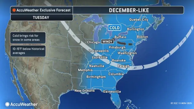

Buffalo, N.Y (WBEN) - A wintry, December-like weather pattern continues to take hold across the Buffalo-Niagara region with below normal temperatures and brisk winds generating lake effect snow off Lake Erie.
"The snow is going to be sticking around, for the most part, through the morning," National Weather Service meteorologist Phillip Pandolfo tells WBEN. "It'll be gradually diminishing as we get to late morning, and especially into this afternoon."
But that's not to say the snow is over for the Buffalo metro area...yet.
The lake effect again gets interesting later Tuesday and into the evening, Pandolfo cautions.
"We're going to see the winds come around to the southwest, and the lake effect band is going to redevelop and quickly swing northward, through the city and up into Niagara County, where it's going to hang until tomorrow morning,"
A Winter Weather Advisory is now posted for northern Erie, Niagara and Orleans counties into Wednesday morning. A Winter Weather Advisory for southern Erie and Cattaraugus County will expire early Tuesday afternoon along with the Lake Effect Snow Warning for Chautauqua County.
The lake effect that moves across the Buffalo metro area Tuesday night won't last long, as temperatures begin to moderate early Wednesday, forcing a changeover from snow to rain.
"It will for sure changeover by mid to late morning(Wednesday)," Pandolfo predicts. "Though it could change over a little bit faster than that as well."
Only a few 'slushy' inches of snow is expected from the lake effect late Tuesday into Wednesday.
Temperatures remain cold and December-like across the region.
"Thankfully today won't be quite as cold as it was yesterday(Monday)," Pandolfo says. "We actually saw record cold high temperatures across much of the region. Thankfully, we'll be getting above the freezing mark today, into the upper 30's, to near 40 in the city."
WINTER WEATHER ADVISORY IN EFFECT UNTIL 10 AM EST WEDNESDAY * WHAT...Lake effect snow. Additional snow accumulations 3 to 5 inches in the most persistent lake snows.
* WHERE...Northern Erie County.
* WHEN...Until 10 AM EST Wednesday.
* IMPACTS...Plan on slippery road conditions. The hazardous conditions will impact the Tuesday and Wednesday morning commutes.
* ADDITIONAL DETAILS...A brief period of moderate snow will be possible in the Buffalo Metro area and the Northtowns late tonight into early Wednesday morning.
PRECAUTIONARY/PREPAREDNESS ACTIONS...
Lake effect snow will fall in relatively narrow bands. If traveling, be prepared for rapidly changing road conditions and visibilities.
WINTER WEATHER ADVISORY NOW IN EFFECT UNTIL 10 AM EST WEDNESDAY
* WHAT...Lake effect snow. Additional snow accumulations 3 to 6 inches in the most persistent lake snows.
* WHERE...Niagara and Orleans Counties.
* WHEN...Until 10 AM EST Wednesday.
* IMPACTS...Plan on slippery road conditions. The hazardous conditions will impact the Tuesday morning and evening commutes.
PRECAUTIONARY/PREPAREDNESS ACTIONS...
Lake effect snow will fall in relatively narrow bands. If traveling, be prepared for rapidly changing road conditions and visibilities.
WINTER WEATHER ADVISORY REMAINS IN EFFECT UNTIL 1 PM EST THIS AFTERNOON
* WHAT...Lake effect snow. Additional snow accumulations 2 to 4 inches in the most persistent lake snows.
* WHERE...Cattaraugus and Southern Erie Counties.
* WHEN...Until 1 PM EST this afternoon.
* IMPACTS...Plan on slippery road conditions. The hazardous conditions will impact the Tuesday morning commute.
PRECAUTIONARY/PREPAREDNESS ACTIONS...
Lake effect snow will fall in relatively narrow bands. If traveling, be prepared for rapidly changing road conditions and visibilities.
LAKE EFFECT SNOW WARNING REMAINS IN EFFECT UNTIL 1 PM EST THIS AFTERNOON
* WHAT...Heavy lake effect snow. Additional snow accumulations 3 to 6 inches in the most persistent lake snows. Greatest snowfall expected along the Chautauqua Ridge axis, with little to no accumulation along the immediate lakeshore. Winds gusting as high as 35 mph will create blowing snow with poor visibilities.
* WHERE...Chautauqua County.
* WHEN...Until 1 PM EST this afternoon.
* IMPACTS...Travel will be difficult. The hazardous conditions will impact the Tuesday morning commute.
* ADDITIONAL DETAILS...Heaviest snow expected early this morning with snowfall rates up to 1-inch per hour.