


DETROIT (WWJ) – After a week that saw multiple rounds of thunderstorms, Metro Detroiters were "treated" to a hot and humid Sunday, with even more storms possible.
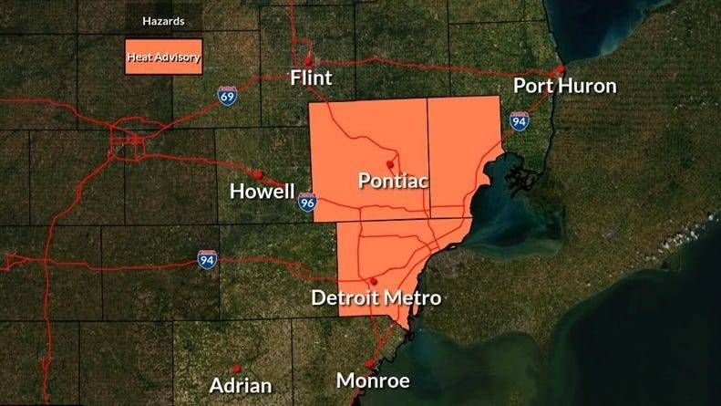
The National Weather Service has issued a Heat Advisory for Oakland, Macomb and Wayne Counties until 10 p.m. Sunday, with temperatures climbing into the low-to-mid 90s and heat indexes approaching 100 degrees.
AccuWeather meteorologist Matt Benz says there could be a thunderstorm or two Sunday afternoon, with the chance increasing later in the night and into Monday.
"If you have any outdoor plans, keep an eye in the sky – we'll see a couple thunderstorms crossing the area," Benz said.
The NWS issued Special Weather Statements for numerous Metro Detroit communities, including Romeo, Milford, Oxford, Lake Orion and others, urging residents to "seek shelter in a sturdy structure," with wind gusts topping 40 mph in some of those areas.
Heading into Sunday night, Benz says, it will continue to be "warm and muggy," along with the chance for thunderstorms.
The NWS says "showers and storms capable of producing heavy rain, lightning, and brief gusty winds will increase in coverage across SE MI into the evening hours."
There could be significant ponding of water on roadways and flood-prone areas. Flooding is possible in low-lying and poor drainage areas.
Areas south of I-69 and west of US-23/I-75 are expected to be primarily impacted through 4 p.m., the NWS said. More storms and showers will be possible across the rest of the area in a "very moist environment."
Rainfall rates could surpass an inch per hour during the peak of the storms, according to the NWS.
While the Great Lakes Water Authority says its regional system is working as designed, it is warning the community – especially those in low lying areas and those who have received previous flooding – that the National Oceanic and Atmospheric Administration (NOAA) is predicting severe storms and excessive rainfall through Monday evening.
"(The system) is currently in dry weather conditions and has capacity to handle the expected flows into the system. In anticipation of the severe weather, GLWA has staffed accordingly," GLWA officials said.
"Given the NOAA prediction and the fact that there have been three 1-in-1,000-year rain events in the Lower 48 states in the last several weeks, GLWA is asking residents in low-lying areas that are prone to flooding during heavy rainfall to remain vigilant and out of an abundance of caution, to remove items of value from their basements."

As for Sunday's high heat, the NWS is reminding the public to be cautious, especially the most vulnerable -- elderly, newborns and children, pregnant women and those with chronic illness.
On Monday, Benz expects times of clouds and sun, but there will also be "drenching thunderstorms." Temperatures on Monday won't be quite as hot, with a high of 87, but the humidity will still be high.
The latest threat of severe weather comes after Metro Detroit was rocked by storms on Wednesday and Thursday. Tens of thousands of DTE Energy customers lost power during last week's storms, which featured high winds and torrential downpours that flooded many area freeways.
Benz says the rest of the week is expected to be "pleasant," with temps ranging from the upper 70s to the mid-80s.


