DETROIT (WWJ) -- It could be hit-and-miss, according to forecasters, but multiple rounds of thunderstorms are in the forecast for the Metro Detroit area, Friday afternoon into Friday night.
The National Weather Service says drenching downpours and large, quarter-sized hail are the most likely threats with discrete storms blowing into Southeast Michigan during the mid to late afternoon — mainly between 2 p.m. and 10 p.m. — but there will be a low risk of a weak tornado as well.
"As we go through the next several hours we'll cloud up, and we're going to see some showers and a thunderstorm this afternoon; temperatures getting up to 80," said WWJ AccuWeather Meteorologist Dean DeVore. "And those showers and some thunder continue on into tonight. Early this evening their could be some hefty ones with downpours, maybe some gusty winds
This forecast covers Macomb, Oakland and Wayne Counties, as well as Genesee, Lapeer, St. Clair-Livingston, Washtenaw, Lenawee, Monroe Midland, Bay, Huron, Saginaw, Tuscola, Sanilac and Shiawassee Counties.
Forecasters say isolated severe storms are possible across the entire region into Friday night, when the threat of damaging winds will increase — with a potential for powerful gusts of up to 60 miles per hour. Some localized flooding is also a concern.
NWS said the storms will move from west to east at 30 mph.
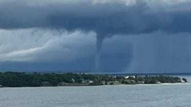
Boaters on Lake St. Clair should note a potential for dangerous waterspouts.
Looking ahead, DeVore said there's a chance for some showers or an isolated thunderstorm early on Saturday, before things dry out for a sticky and humid Saturday afternoon. Sunday looks like a nicer day, less humid, with some sun and a high of around 81 degrees.