(WWJ) Keep an eye on the sky and prepare to take cover quickly, as forecasters warn that storms in metro Detroit on Wednesday could do some serious damage.
The National Weather Service has issued a Severe Thunderstorm Watch for a portion of the state — including metro Detroit — until 8 p.m.
NWS forecasters say the primary threat with these storms will be damaging winds up to 70 miles per hour... although there are already some reports of powerful gusts exceeding that speed.
Isolated tornadoes, large hail up to 1 inch, heavy downpours and lightening are also a potential threat throughout Southeast Michigan, NWS said.
The storms may come in two rounds
NWS said the first window in the metro Detroit area would be between 2 p.m. and 7 p.m. Wednesday, and the second window would be from 9 p.m. Wednesday until 2 a.m. Thursday.
In the first round, hitting metro Detroit mid-afternoon, a gust of 75 miles per hour was reported at Selfridge Air National Guard Base in Macomb County. Gusts of over 60 miles per hour were reported at Metro Airport and Willow Run Airport near Ypsilanti, and a gust of 58 miles per hour was reported in Ann Arbor.
Trees were also blown down in Lenawee County where winds topped 70 miles per hour.
By 4:30 p.m., there were around 330,000 power outages reported in metro Detroit, with storms moving through the area. [CHECK THE DTE OUTAGE MAP]
An additional 220,000 outages were reported by Consumers Energy.

Metro Detroiters are urged, as always, to have a severe weather safety plan in place. As a reminder: Stay 20 feet away from, and never touch any downed or damaged power lines.
Meanwhile, it'll be hot.
A heat advisory is has been issued, in effect from 2 p.m. until 8 p.m. Wednesday. The advisory includes Livingston, Oakland, Macomb, Washtenaw, Wayne, Lenawee and Monroe counties, with heat indexes up to 100 degrees expected.
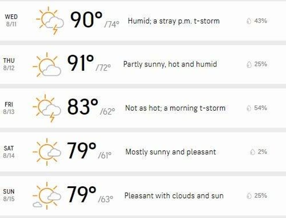
Looking ahead, WWJ AccuWeather Meteorologist Dean DeVore says it'll stay steamy and humid in metro Detroit for the next couple of days, with another around of storms possible on Friday.
The good news: "That front on Friday brings the heat and humidity down. Temperatures (will be) much nicer... lower humidity and some sunshine both days of the weekend; the highs getting up to 80 to 84," DeVore said.
"What a relief after these heat and humidity and thunderstorm stretch we've been through!"
Here's the AccuWeather 5-day forecast for Detroit:
 AccuWeather
For the latest updates, keep your radio tuned to WWJ Newsradio 950 for traffic and weather, every 10 minutes on the 8s. Want to listen to WWJ on your phone or tablet? Download the FREE Audacy app.