SOUTHFIELD (WWJ) -- Severe thunderstorms with hail, damaging wind gusts and flooding downpours are hitting Southeast Michigan after scorching heat and humidity baked Metro Detroit earlier in the day.
Wednesday's wild weather caused multiple freeway closures due to flooding across the area, including I-75 in both directions between 8 Mile and 12 Mile, eastbound I-94 after I-696 and westbound I-94 after 12 Mile.
A crash closed I-75 in Downtown Detroit and a jackknifed semi left I-75 in Monroe closed. Listen LIVE for the latest traffic updates every 10 minutes on the :08s.
 Terrance Vails / WWJ
Severe Thunderstorm Warnings were in effect in Macomb and Oakland Counties, while Washtenaw and Wayne Counties were under a warning until 7:30 p.m.
Flood Advisories in Macomb, Oakland and Livingston Counties have expired.
Wednesday's storms knocked out power to more than 100,000 homes and businesses across the state.
As of 10:30 p.m., there were more than 28,000 DTE Energy customers without power across Southeast Michigan. The largest outages were in Sterling Heights, southern Monroe County and the Oxford-Lake Orion area.
CHECK THE DTE OUTAGE MAP FOR THE LATEST UPDATES
Elsewhere in Michigan, Consumers Energy said around 9 p.m. Wednesday, they had about 84,000 homes and businesses without power.
By 6:30 p.m., there were already reports of damaged trees and flooding across the area, causing a mess on the roads.
In addition to freeway closures and crashes, there have been numerous reports of downed trees and power lines.
 Tree down in BloomfieldWWJ Photo
The severe weather came after a spell of serious heat across the area.
"Temperatures are expected to reach between 90-95 degrees this afternoon. Heat indices topping out around 100 degrees for a couple of hours before showers and thunderstorms likely develop later in the day," the NWS said earlier in the day.
Officials reminded residents to drink plenty of fluids, stay in an air-conditioned room, stay out of the sun, and check up on relatives and neighbors.
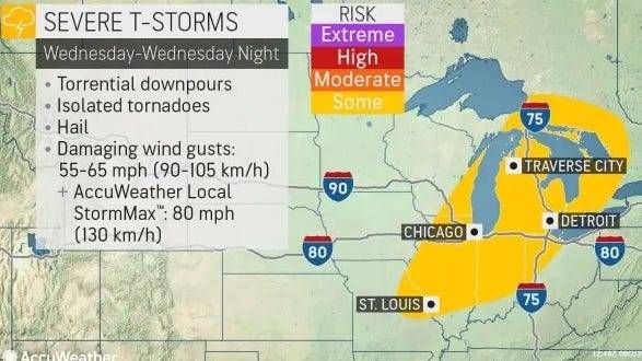
As high temperatures persisted throughout the day and a strong cold front swept in through the afternoon hours, scattered strong to severe thunderstorms developed across the area.
"The clash of cooler, drier air colliding with high heat and humidity ahead of a cold front will be the primary culprits for the potentially damaging thunderstorms," explained AccuWeather Senior Meteorologist Mike LeSeney.
"Damaging winds to 65 mph and hail larger than one inch in diameter are the main threats, the NWS said on Wednesday. "An isolated tornado can not be ruled out with the first storms that develop Wednesday afternoon, likely north of M-59."

Although there are many variables at play that could lead to different weather scenarios, forecasters said residents should prepare now for severe storms.
"Be weather aware and ready to act," the NSW service said.
AccuWeather Meteorologist Dean Devore said the heat will diminish into Thursday with showers and a rumble of thunder possible. The humidity will still stick around with highs in the low to mid-80s.
While the threat for severe weather will have diminished, meteorologists said heavy rain will be the primary hazard with any storms the area sees on Thursday.