


The National Weather Service has issued a flash flood watch for Southeast Louisiana.
"Numerous showers and thunderstorms are expected today through Friday night. 2-6"+ of rain possible," forecasters at the NWS New Orleans office caution.
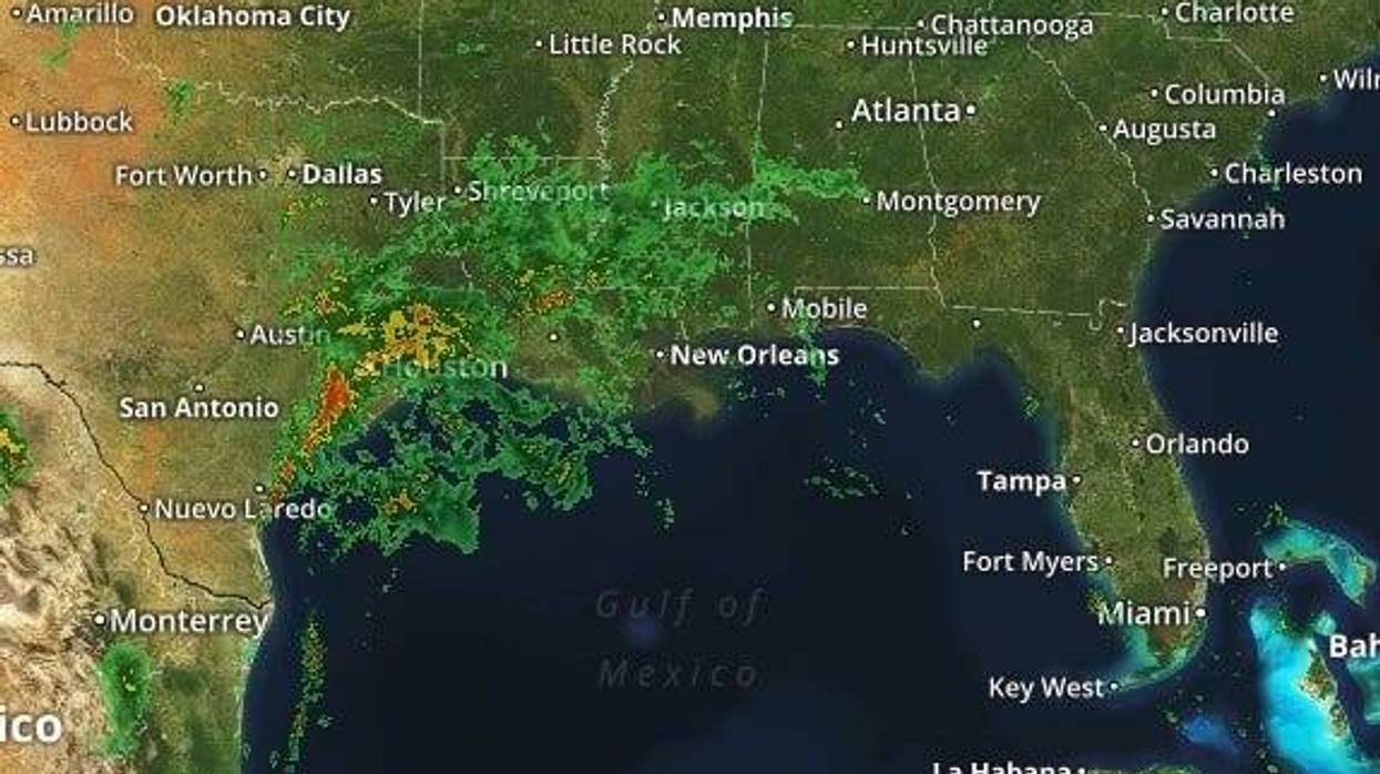
Numerous showers and thunderstorms are expected today through Friday night. 2-6"+ of rain possible now through then. A flash flood watch in effect tonight through Thursday. The graphic below shows where the heaviest rain is expected. pic.twitter.com/JRTtKymurI
— NWS New Orleans (@NWSNewOrleans) June 5, 2019New Orleans Emergency Management is urging residents to be ready.
Prep for possible heavy rain in #NOLA Thursday: clean out gutters, down spouts & in front of catch basins and stay weather aware. More: https://t.co/Q0NcMm8lTT https://t.co/ncQ6sHViKG
— NOLA Ready (@nolaready) June 4, 2019All of this moisture is thanks to an area of disturbed weather in the Gulf that we've been watching.
"Invest 91 has become a trough of low pressure as it sits off the South Texas Coast," WWL-TV Meteorologist Dave Nussbaum explained. "It will start to send some deep tropical moisture our way today."
He says today will see scattered showers and thunderstorms.
"Expect a few downpours throughout the day. High temperatures will be held down into the upper 80s."
The bulk of the rain gets here tomorrow.
"Even deeper tropical moisture arrives on Thursday and Friday as an upper-level low and trough of low pressure sits over the Plains States. They will pull up the moisture from what was Invest 91 right over Louisiana. This will give us scattered to numerous showers and storms with heavy rain," according to Nussbaum.
A Moderate Risk (Level 3/4) for excessive rainfall is now expected for ALL of SE Louisiana on Thursday. We could pick up 2-3”+ of rain. That will lead to some flash flooding issues around the #NewOrleans to #BatonRouge areas. Stay weather aware! #lawx #BeOn4 @WWLTV pic.twitter.com/FgAR3iApv9
— Dave Nussbaum WWL-TV (@Dave_Nussbaum) June 5, 2019- Weekend Forecast: The deeper tropical moisture will remain over us this weekend as a cold front and low pressure move across Louisiana Saturday and Sunday. Expect more scattered showers and storms with some heavy rain on Saturday, but fewer storms are expected on Sunday with a little more sun. High temperatures will be around 90 each day. A cold front will move through on Sunday Night and this will gradually put an end to the rain early next week.
- Tropical Update: Invest 91 is not expected to develop into anything as it remains off the South Texas Coast. It will just bring heavy rain to SE TX and much of LA over the next few days. Elsewhere...the tropics are quiet.
- Mississippi River update: The Army Corps has pushed back the tentative opening of the Morganza Spillway to Sunday, June 9. Upriver at Baton Rouge and Red River Landing, the Mississippi River crest forecasts have been pushed back to June 14. That’s because levee breaches in Arkansas have let out some of the river water, and it is not rising as quickly. River levels are forecast to stay near steady for New Orleans and Reserve.
Here is a look at the 7 Day Forecast for the New Orleans area: WWLTV #lawx pic.twitter.com/qfsH2vWjEj
— Dave Nussbaum WWL-TV (@Dave_Nussbaum) June 5, 2019TODAY:Mostly cloudy, warm and humid with a 60% chance for scattered showers and thunderstorms. Highs around 88 feeling like middle 90s. Wind S 6-12 mph.
TONIGHT:Mostly cloudy, mild and humid with a 40% chance for scattered showers and thunderstorms. Lows around 79. Wind S 5-10 mph.
THURSDAY:Mostly cloudy, warm and humid with a 80% chance for showers and thunderstorms. Some heavy rain likely. Highs around 85 feeling like low 90s. Wind SE 6-12 mph.
FRIDAY:Mostly cloudy, warm and humid with a 70% chance for showers and thunderstorms. Heavy rain likely. Lows around 78. Highs around 88 feeling like low 90s.
SATURDAY:Sun/cloud mix, hot and humid with a 60% chance for scattered showers and storms. Lows around 78. Highs around 90 feeling like middle 90s.
SUNDAY:Sun/cloud mix, hot and humid with a 40% chance for scattered showers and storms. Lows around 77. Highs around 92 feeling like middle to upper 90s.
MONDAY:Sun/cloud mix, hot and humid with a 30% chance for spotty showers and storms. Lows around 78. Highs around 91 feeling like mid 90s.
TUESDAY:Partly cloudy, very warm and a little less humid. Lows around 75. Highs around 89 feeling like low 90s.


