While heat records keep falling, some brief relief is headed our way.
"We finally have some changes to talk about this week and for the better!" WWL TV Meteorologist Payton Malone said.
He says we have had the most consecutive days ever with 100 degrees or more with four over the past four days. We have also had nine days this year with 100 or higher. Shattering the old record of five 100 degrees day.
Now the good news...
"You will notice is the lower humidity Wednesday and Thursday," Malone insists. "It will be 95 degrees, only feeling like up to 97."
He says that's thanks to a front.
"The ridge is going to break down, the front is going to slide in... and it's going to be a little less hot."
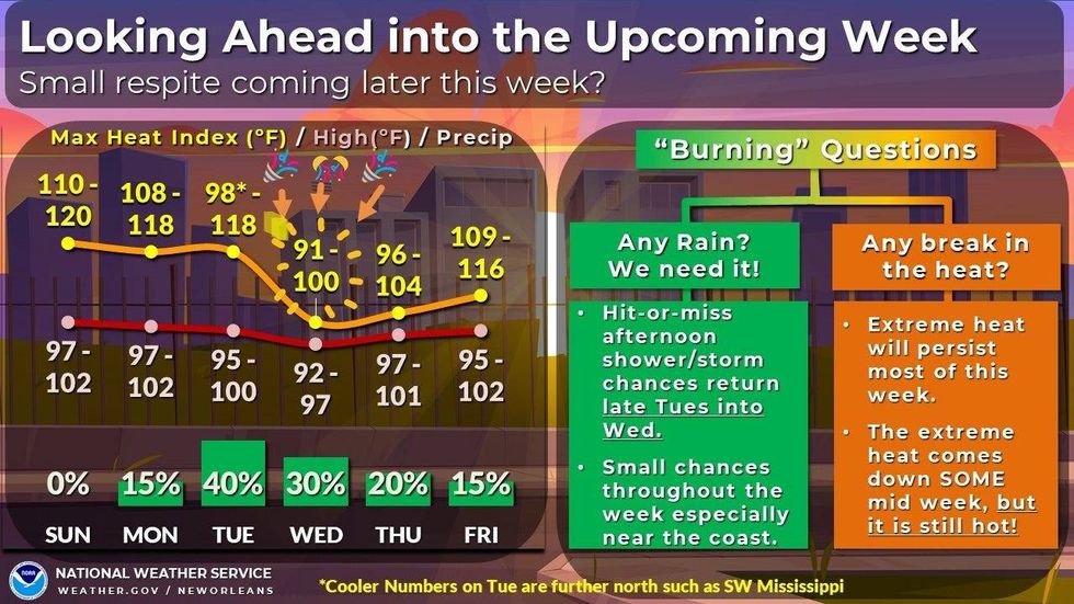 NWS
NWS
Before that we are expecting dangerous highs around 100 today and tomorrow.
Detailed Forecast
TODAY:
Partly sunny. 20% chance scattered showers and storms. Very hot and humid. Low: S 82, N 80. High: 100.
TUESDAY:
Partly sunny. 40% chance scattered showers and storms. Hot and humid. Low: S 80, N 78. High: 100.
WEDNESDAY:
Partly sunny. 20% chance scattered showers and storms. Less humid! Low: S 77, N 75. High: 95.
THURSDAY:
Hot, but not too humid. Low: S 77, N 75. High: 98.
FRIDAY:
Hot with slightly higher humidity. Low: S 78, N 76. High: 99.
SATURDAY:
Partly sunny. 20% chance scattered showers and storms. Hot and humid. Low: S 79, N 76. High: 99.