

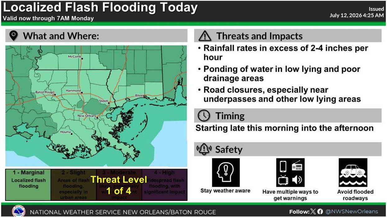

After parts of New Orleans received eight inches of rain on Saturday, the city and all of Southeast Louisiana are bracing for even more rain and the possibility of flooding.
We expect more rounds of torrential rain today, tomorrow, and Sunday, with some of these downpours producing four to six inches of rain--or more--per hour, leading to flash flooding and street flooding in some areas. Rainfall totals will vary across the region, but widespread totals of two to five inches of rain are possible through the middle of the week.
These storms will also feature some severe elements, such as lightning, hail, and waterspouts.
Because of the threat of rain on Sunday, New Orleans city leaders are allowing residents to park in the neutral ground until 9 p.m. Drivers who take advantage of neutral ground parking are reminded not to block intersections, bike paths, streetcar paths, or sidewalks.
Meanwhile, the Sewerage and Water Board of New Orleans is echoing calls made by Mayor Helena Moreno for residents to clear trash and debris from catch basins in front of their homes and businesses to allow rainwater to drain efficiently. According to an update on the SWB's social media pages, 87 of the agency's 93 pumps are online. Two of those inoperable pumps are in New Orleans East. Another is in Algiers, while the last is located along the 17th Street Canal.
Stay weather aware over the next 72 hours. Avoid traveling in these severe conditions and driving on flood roadways.
Once the wetter pattern pushes out of the area, we'll return to our typical hot and humid summer pattern. However, we'll keep a 10- to 20-percent rain chance in the forecast because, as is typical in Louisiana during the summer, pop-up showers and storms are possible thanks to daytime heating.
SUNDAY:
80% chance numerous showers and storms. Heavy rain likely. Cloudy, muggy. High: 87. Winds: SW 5-10 mph.
MONDAY:
80% chance numerous showers and storms. Heavy rain likely. Cloudy, muggy. Low: S 76, N 73. High: 86.
TUESDAY:
70% chance numerous showers and storms. Heavy rain likely. Cloudy, muggy. Low: S 76, N 73. High: 88.
WEDNESDAY:
Partly cloudy. 20% chance spotty shower/storm. Hot & humid. Low: S 76, N 73. High: 92.
THURSDAY:
Partly cloudy. 10% chance spotty shower/storm. Hot & humid. Low: S 77, N 74. High: 93.
FRIDAY:
Partly cloudy. 10% chance spotty shower/storm. Hot & humid. Low: S 77, N 74. High: 94.
SATURDAY:
Partly cloudy. 20% chance spotty shower/storm. Hot & humid. Low: S 78, N 74. High: 94.