


Winter Storm Fern has arrived in the Upstate. The City of Greenville says "Sleet and Freezing Rain Arrive; Residents Urged to Stay Home"
Residents awoke to a Greenville city-wide white out on Sunday morning. Sleet is covering surfaces but not power lines. Precipitation rates will be highest early this morning. Another round will move in this afternoon.
To get the latest weather forecast from the Newstalk 98.9 WORD Weather Center, click HERE.
Roads currently have a significant amount of ice and sleet, making them very slick. Please continue to find comfort at home.
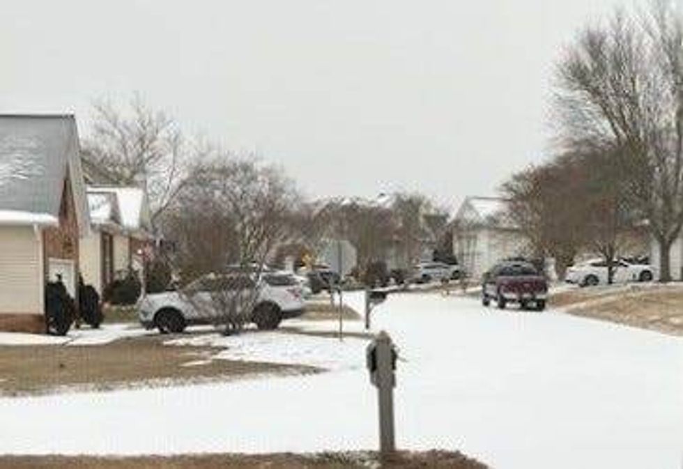 Winter Storm Fern - Simpsonville - Sunday morning, 1/25/26Stacie Bartro
Previously shared below from SCDNR (1/24/26) - Key Points:
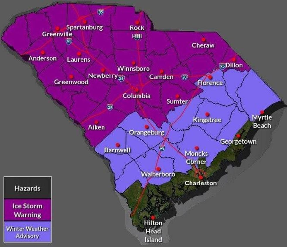
An Ice Storm Warning is in effect for the Upstate, Catawba Region, most of the Central Savannah River Area (CSRA) and Midlands, and the northern part of the Pee Dee region. A Winter Weather Advisory is in effect for the rest of the Pee Dee except for coastal Georgetown County and most inland areas of the Lowcountry. A Winter Storm Watch remains in effect for Darlington and Dillon Counties. This will become an Ice Storm Warning or Winter Weather Advisory soon.
 SCDNR
SCDNR
 SCDNR
SCDNR
Sleet and freezing rain will spread over the Upstate and Catawba Region tonight. Sleet is likely to accumulate an inch or so along and north of I-85 from Greenville northeastward before a change to freezing rain, while areas southeast of I-85 see less sleet with an earlier transition to freezing rain. Freezing rain and drizzle continue through Sunday before ending Sunday night. Tree and power line damage is likely to be widespread, causing potentially long-lasting power outages. Travel will be dangerous through at least Monday morning. A windy period Sunday night and Monday behind the storm will exacerbate the potential for tree and power line damage. Across the northern CSRA, the northern Midlands, and northern Pee Dee, the storm begins with sleet for a while Saturday evening, with a small accumulation possible. However, freezing rain will dominate most of Saturday night and Sunday. Widespread tree and power line damage is possible, and travel will be hazardous, potentially through Monday morning. Power outages could be lengthy. A windy period Sunday night into Monday may exacerbate the potential for tree and power line damage. Along I-20, ice buildup will lead to scattered tree and power line damage, and travel will become hazardous, especially on elevated roads. Temperatures rise above freezing Sunday afternoon, ending the threat for icy travel, with intermittent light rain or drizzle the rest of the day. Sunday night brings a round of more substantial rain and perhaps a thunderstorm. Areas south of the I-20 Corridor in the CSRA, Midlands, and Pee Dee will see a lesser ice buildup Saturday night through Sunday morning, but isolated tree and power line damage is possible. Roads and sidewalks will have icy patches, especially on elevated surfaces. Temperatures will likely rise above freezing by midday Sunday, ending the threat for icy travel, with intermittent light rain or drizzle the rest of the day. Sunday night brings a round of more substantial rain and perhaps a thunderstorm. The inland Lowcountry and Grand Strand primarily see rain with temperatures above freezing Saturday night through Sunday. However, freezing rain will occur over the region for a time Saturday night and early Sunday with temperatures dropping to near freezing. Elevated road surfaces can remain slippery for a few hours, but the risk of tree and power line damage is low. The coastal Lowcountry will most likely remain above freezing and see only rain. The Lowcountry will see thunderstorms late Sunday and Sunday night as warm air surges into the region; there may even be a risk of isolated damaging winds and isolated tornadoes. Continued cold early next week behind the storm will lead to slow melting where there is a substantial sleet accumulation. Burst pipes and water mains will be a concern over much of the state, and those with no power or a backup heating source will experience severe hardship.
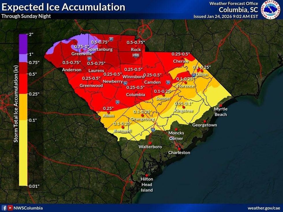 Expected Ice AccumulationSCDNR
Extreme cold will settle in behind the storm for early next week, and Monday night and Tuesday morning will bring the Upstate the coldest air we've seen in years; mighty cold over the rest of the state as well:
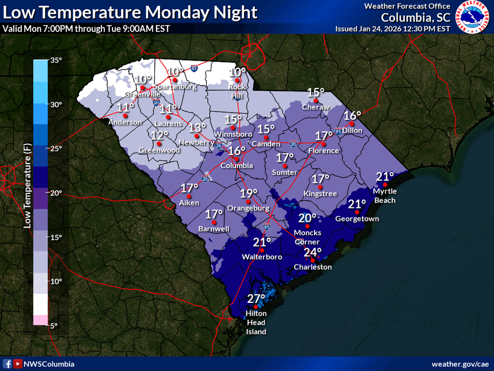 SCDNR
SCDNR
The extreme cold will slow the melting of the glacier covering the Upstate early next week. Slippery travel will probably linger into Tuesday morning and may even hold on into Wednesday if enough sleet falls.
Get prepared. SCEMD's SC Winter Weather Guide is a good starting point, and you can get more tips on winter storm preparedness at ready.gov. Pay close attention to the generator safety and kerosene and propane heater safety tips; carbon monoxide is quite the villain. Other thoughts:
It isn't going to be a fun snow day this weekend. It's going to be a crippling ice storm. Adjust your mindset accordingly. You own an internal combustion engine generator? Good! Most of y'all haven't used it in a while. You ought to test it to make sure it still runs. You have one of those big battery packs and solar panels for it? Good! Make sure it's charged up before the storm. Make sure you understand its limitations. Will it power your microwave? How long will it power what you want it to run? Unfortunately, it's going to be cloudy all weekend; there will be no free solar power until Monday. With the roads icy and trees and power lines coming down, you want to be careful with everything you do this weekend. Emergency response will be delayed, and delays may be lengthy. You don't want to suffer a serious injury.


