
Severe Ice Storm This Weekend - South Carolina Department of Natural Resources
Key Points:
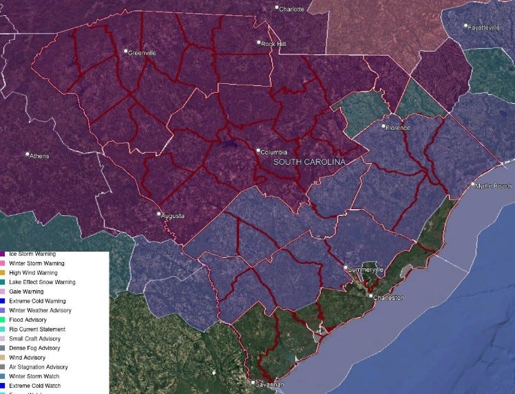
An Ice Storm Warning is in effect for the Upstate, Catawba Region, most of the Central Savannah River Area (CSRA) and Midlands, and the northern part of the Pee Dee region. A Winter Weather Advisory is in effect for the rest of the Pee Dee except for coastal Georgetown County and most inland areas of the Lowcountry. A Winter Storm Watch remains in effect for Darlington and Dillon Counties. This will become an Ice Storm Warning or Winter Weather Advisory soon.
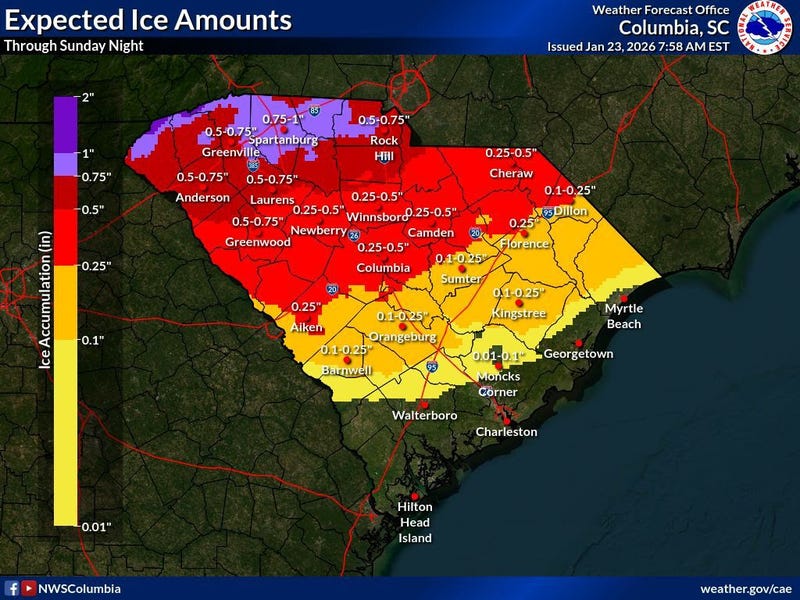
The Upstate and Catawba Region will see precipitation begin late Saturday, likely as sleet. Any snow that falls would be near the NC state line for a brief time at the onset. Sleet is likely to accumulate an inch or two, possibly more, along and north of I-85 before a change to freezing rain, while areas southeast of I-85 see less sleet with an earlier transition to freezing rain. Tree and power line damage is likely to be widespread, causing potentially long-lasting power outages. Travel will be dangerous Saturday night through at least Monday morning, possibly through Tuesday morning. A windy period Sunday night and Monday behind the storm will exacerbate the situation. Across the CSRA, the Midlands, and northern Pee Dee, the storm begins with sleet for a while Saturday evening, with a small accumulation possible. However, freezing rain will dominate most of Saturday night and Sunday morning. Temperatures falling to the 20s will result in efficient ice accretion. Ice buildup will lead to scattered tree and power line damage, and travel will become hazardous, especially on elevated roads. Damage could be widespread across the northern CSRA and northern Midlands, with potentially lengthy power outages. A windy period Sunday night into Monday may exacerbate the situation. Extreme cold will follow the storm, with lows in the teens Monday night into Tuesday morning. Areas south of the I-20 Corridor in the CSRA, Midlands, and Pee Dee will see a lesser ice buildup Saturday night through Sunday, but isolated tree and power line damage is possible. The inland Lowcountry and Grand Strand primarily see rain Saturday night through Sunday, but freezing rain will occur over the region Saturday night and early Sunday. Elevated road surfaces can become slippery, but the potential for tree and power line damage is low. The coastal Lowcountry will most likely remain above freezing and see only rain. The Lowcountry will see thunderstorms late Sunday and Sunday night as warm air surges into the region; there may even be isolated damaging winds with the storms.Continued cold early next week behind the storm will lead to slow melting, especially in areas where a substantial sleet accumulation occurs. Burst pipes and water mains will be a concern, and those with no power or a backup heating source will experience severe hardship.
The worst-case scenario is the forecast for this weekend's winter storm for the Upstate, Catawba Region, and adjacent counties. A severe ice storm will cause dangerous travel and widespread tree and power line damage. Lesser but still significant damage from the ice and slick roads will affect areas further south to I-20. South of there, tree and power line damage becomes isolated, with patches of ice on the roads.
Ahead of the storm:
Some places will see a shower through this evening in the mild air ahead of a cold front moving into the state. The front will send an arctic air mass into South Carolina later tonight, sending temperatures below freezing over much of the state during this weekend's storm.
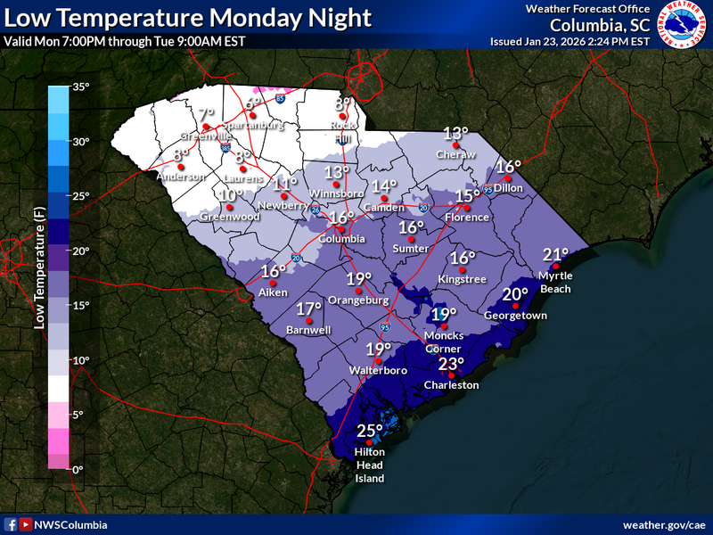
Extreme cold will settle in behind the storm for early next week, and Monday night and Tuesday morning will bring the Upstate the coldest air we've seen in years:
That would be the coldest the I-85 Corridor has seen in a long, long time, since January 7, 2014, in fact (when it got down to 5° at GSP Airport). It's going to be bitter over the rest of the state, too.
The extreme cold will slow the melting of the glacier covering the Upstate early next week. Slippery travel will probably linger into Tuesday morning and may even hold on into Wednesday if enough sleet falls.
Get prepared. SCEMD's SC Winter Weather Guide is a good starting point, and you can get more tips on winter storm preparedness at ready.gov. Pay close attention to the generator safety and kerosene and propane heater safety tips; carbon monoxide is quite the villain. Other thoughts:
It isn't going to be a fun snow day this weekend. It's going to be a crippling ice storm. Adjust your mindset accordingly. You own an internal combustion engine generator? Good! Most of y'all haven't used it in a while. You ought to test it to make sure it still runs. You have one of those big battery packs and solar panels for it? Good! Make sure it's charged up before the storm. Make sure you understand its limitations. Will it power your microwave? How long will it power what you want it to run? Unfortunately, it's going to be cloudy all weekend; there will be no free solar power until Monday. With the roads icy and trees and power lines coming down, you want to be careful with everything you do this weekend. Emergency response will be delayed, and delays may be lengthy. You don't want to suffer a serious injury.