We're seeing some temporary higher wind gusts occurring along the back edge of the precipitation band now exiting the eastern part of the Metroplex. This is likely a modest wake low event ongoing. Winds gusted to 40 mph at RedBird, and 36 mph at both Arlington and FTW Meacham. These winds should subside shortly as the precip band recedes eastward.
A taste of spring weather occurred across the northern parts of the Metroplex late Thursday evening. Terrible hail damage occurred in northern Tarrant, Denton and Collin counties. Material things can be fixed and replaced, but I know it's a pain in the rear. Things will quiet down over the next several days, but we still have more rain in the forecast. Nothing severe though.
Hey at least it's Friday! Most of the rain has moved out of the area this morning, but there'll be a few showers moving in from the southwest during the day. Our cold front that stalled over us overnight has now gotten the kick it needs to head south of the area. It'll be windy and cooler today with highs and the low to mid 60s.
Tonight will be uneventful with plenty of cloud cover and breezy conditions. There may be a few showers moving through, but not a big deal.. yet.
Saturday's a big deal for many residents across the Metroplex. The annual Greenville Avenue St. Patty's Day Parade starts late tomorrow morning. As of now, I haven't officially heard if this will be canceled or not, but there's going to be a lot of rain moving through the area starting late tomorrow morning through the evening hours. Nothing will be severe, but some areas could pick up at least a half inch or more of rain before all is said and done. Temperatures will remain in the low 60s all day long. It'll be a cool day with lighter wind.
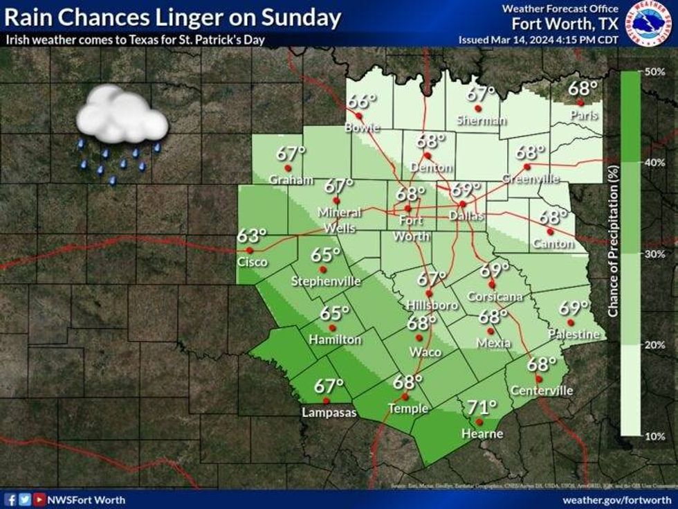
Clouds will stick around on Sunday, as that upper level low continues to park itself in the desert southwest. Another spoke of energy and another cold front will arrive the second half of the day. There will be some rain around, but the heaviest rain as of now looks to be south of the Dallas-Fort Worth area. Stay tuned.
Sunday's cold front will dry the air out a little bit on Monday and Tuesday with some peeks of sunshine. Afternoon highs will be in the mid to upper 60s. Average for this time of the year.
 NWS
NWS
Spring officially arrives by the middle of next week and rain chances look to increase late Wednesday and into Thursday....as that system well off to our west finally gets the kick it needs to move across the area. It's still too early to tell if anything will be severe.
Have a great Saint Patrick's Day weekend and I'll talk to you soon!
___________________________
7-Day Headlines:
* DFW Airport reached 81 yesterday.
* Scattered showers today.
* Widespread non severe showers and storms on Saturday. GA Parade impacted.
* More showers on Sunday, heaviest south of DFW.
* Near average temperatures.
* Dry Monday, more rain possible late Wednesday and Thursday.
_____________________________________________________
*Yest Rain: Trace; Yest High: 81 Low: 69
*Today's Averages: High: 68; Low: 48
*Record high: 86 (1943); Record low: 28 (1912, 1913, 1943)
__________________________________________________________
*March Rain: 2.77"; Surplus: 1.25"
*2024 Rain: 7.91"; Surplus: 1.10"
*Sunrise: 7:36am; Sunset: 7:37pm
__________________________________________________________
Today: Cloudy, breezy and cooler. Scattered showers. Severe weather threat is over. High: Mid 60s. Wind: North 15-25, G30 mph.
Tonight: CLoudy and cool. A few showers. Low: Mid 50s. Wind: NE 15-25 mph.
Tomorrow: Cloudy and cool. Widespread showers and isolated non severe storms throughout the day. Greenville Ave. Parade will be impacted. High: Low 60s. Wind: NNE 5-10 mph.
St. Patty's Day: Cloudy and cool. Scattered showers. Heaviest rain south of DFW. Late day cold front. High: Mid to upper 60s.
Monday and Tuesday: Partly cloudy and seasonable. Highs: Mid to upper 60s.
Wednesday and Thursday: Rain may return late Wednesday into Thursday. High: Low to mid 70s.
LISTEN on the Audacy App
Tell your Smart Speaker to "PLAY 1080 KRLD"
Sign Up to receive our KRLD Insider Newsletter for more news
Follow us on Facebook | Twitter | Instagram | YouTube