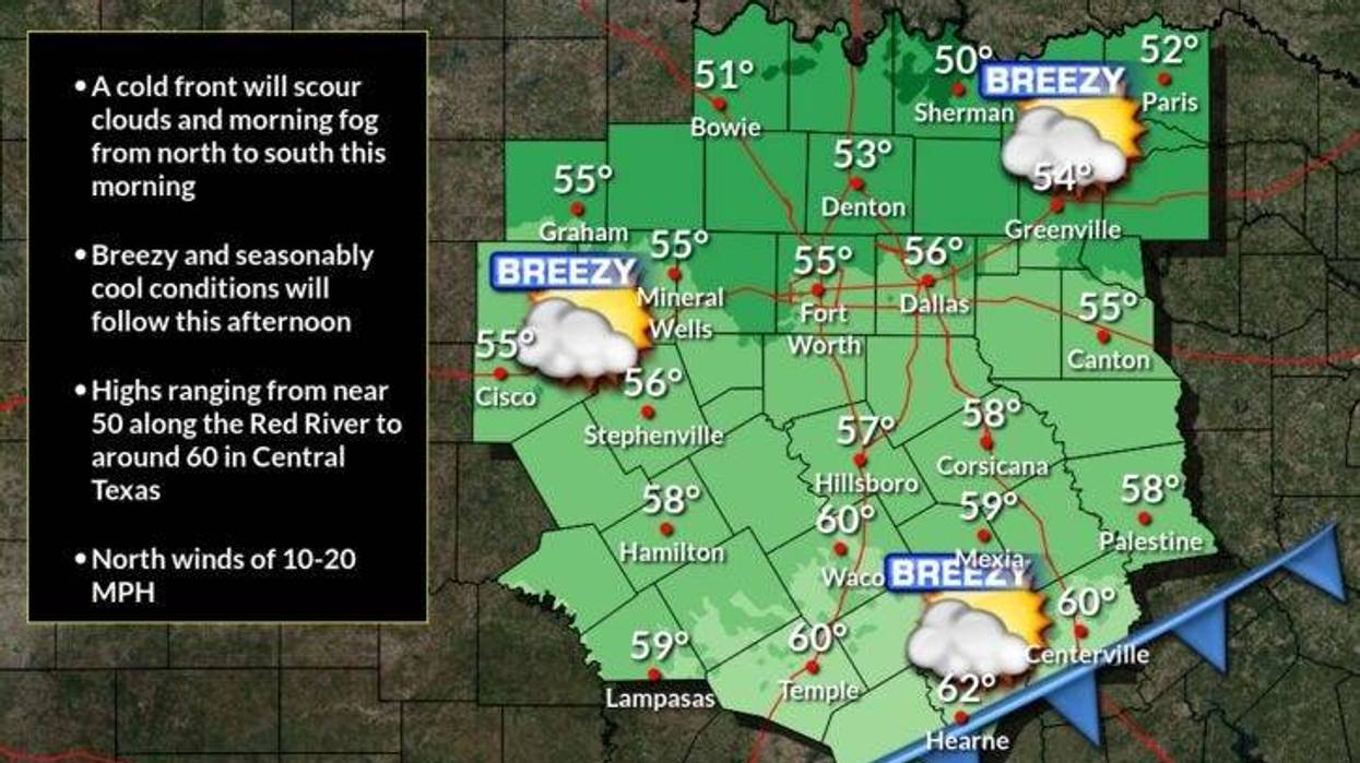
Fog moved out Thursday morning and the sun peaked through across North Texas. Temperatures began in the upper 40s with a north wind picking up to 10 mph. It will be sunny, breezy, and cool on Thursday with afternoon highs in the mid-50s.
Thursday night will be clear and cold. Temperatures will be slightly below freezing away from town, with patchy frost in areas.
Clouds increase rapidly Friday and light rain, possibly mixed with some sleet pellets, will begin to fall during the afternoon. Temperatures will hover in the low 50s.
On-and-off showers will continue Friday night through Sunday afternoon. Average rainfall totals will be around half an inch. Higher totals are possible east and south of the Dallas-Fort Worth area.
Temperatures will be chilly on Saturday. Readings will hover in the mid-40s all day. Skies will slowly clear from west to east on Sunday, with afternoon highs jumping up to near 60 degrees. Cooler temperatures are possible east of DFW, depending on how fast the clouds move out.
Monday is our transition day and a spectacular one at that. It will be sunny with a high near 70 degrees.
By early Tuesday morning, clouds will invade and so will a strong cold front. It doesn't look like we'll see any precipitation along the front. We'll start the morning off in the low to mid-50s and slowly fall into the upper 40s by late afternoon. It stays cool on Wednesday as well with highs in the low to mid-50s with sunshine.
 Rainfall forecast for North TexasNational Weather Service
7-Day Headlines
* DFW Airport reached 53 on Wednesday with 0.17 inches of rain.
* Thursday morning dense fog west and southwest until 7 a.m. The cold front has moved through dry.
* A beautiful day on Thursday.
* On and off rain Friday afternoon through Sunday afternoon.
* Rainfall totals around 0.50", isolated higher totals.
* Clearing late Sunday, near 70 degrees on Monday.
* Colder Tuesday and Wednesday, but not terribly cold.
_____________________________________________________
*Wednesday Rain: 0.00"; Yest High: 53; Low: 50
*Thursday's Averages: High: 60; Low: 40
*Record high: 81 (1951,2022); Record low: 18 (1950)
________________________________________________________
*December Rain: 0.15"; Deficit: "
*2024 Rain: 35.90"; Surplus: 1.40"
*Sunrise: 7:17am; Sunset: 5:21pm
________________________________________________________
Thursday: **Dense Fog Advisory west and SW until 7 a.m.** Morning fog, afternoon sun. High: Mid 50s Wind: North 10-20 mph.
Thursday night: Clear and cold. Patchy frost. Protect plants and pets. Low: 28-34. Wind: NE 5-10 mph.
Friday: Increasing clouds and cool. Light sleet/rain early, then scattered showers into the evening. High: Low 50s. East 5 mph.
Saturday: Scattered showers and isolated storms. Chilly! High: Mid-40s.
Sunday: Chance of showers early, shifting east during the day. A slight decrease in clouds. High: Near 60.
Monday: Sunny, with a brief warm-up. High: Near 70.
Tuesday: Morning DRY cold front. Turning windy and colder. Falling temperatures into the 40s by evening. High: Low to mid-50s early.
Wednesday: Sunny, breezy and cool. High: Low to mid-50s.
LISTEN on the Audacy App
Tell your Smart Speaker to "PLAY 1080 KRLD"
Sign Up to receive our KRLD Insider Newsletter for more news
Follow us on Facebook | Twitter | Instagram | YouTube