
Triple-Digit Heat Continues!
Well, the triple-digit heat will continue through the weekend and into Tuesday, with a little break from the heat Wednesday and Thursday. Then we’re back near 100° Friday through next weekend!
Good morning, everyone! Hope you had a great weekend, and welcome to Monday! We’re waking up to clear skies with temperatures in the upper 70s to low 80s — something we’ve been experiencing what seems like forever!
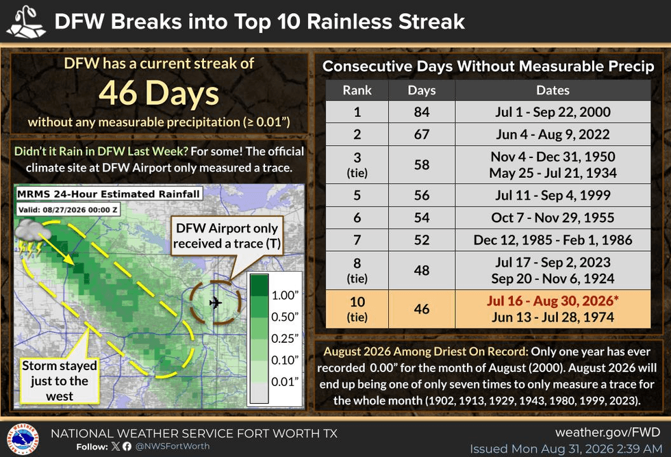
And unfortunately, the forever 100° temperatures continue again today and tomorrow. High pressure remains firmly in control in the upper levels of the atmosphere, and with south winds at 10–15 MPH, the combination of 46 consecutive days without measurable rainfall, low relative humidity, and dry vegetation means critical fire danger remains a major concern across North Texas.
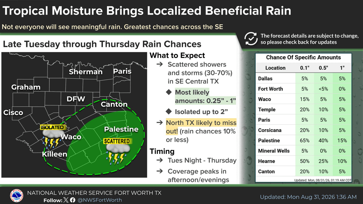
But there may finally be a little relief coming Wednesday and Thursday in the form of increased cloud cover and precipitation.
TROPICS UPDATE: The National Hurricane Center is monitoring an area of disturbed weather now a couple hundred miles south of New Orleans in the northern Gulf. It’s moving northwest at around 10 MPH.
The Hurricane Center is sending out an Air Force reconnaissance aircraft later this morning to investigate the system, look for a low-level circulation, and determine its wind speeds.
We could have a tropical depression or even a tropical storm on our hands by Tuesday morning. If it becomes a named storm, the name would be Edouard.
Due to the system’s close proximity to the coast, I don’t currently expect this to become a major tropical storm or a hurricane. But as we all know… stranger things have happened!
Residents along the Upper Texas Coast and Northwestern/Western Louisiana coastline need to monitor this system closely.
It could bring some much-needed rainfall to the region, but there is also a threat for flooding, dangerous surf, and strong rip currents through Tuesday afternoon before landfall.
The system should begin bending more toward the northwest and eventually northward Wednesday into Thursday. Its track could potentially take it right up Interstate 45 toward the Dallas-Fort Worth area.
However, high pressure dominating our weather here in North Texas should cause the system to weaken significantly as it moves toward DFW. Even so, it could potentially break our approaching 50-day streak without measurable rainfall.
Hopefully, we finally get some rain! But there could be Flood Watches along portions of the Southeast Texas Coast, with widespread rainfall of 3–5 inches possible and locally higher totals.
I’ll continue monitoring this system closely over the next 48–72 hours, bringing you updates and radar trends right here on KRLD and across all of my Facebook pages.
After Thursday, it looks like this system will get zapped by high pressure, which will return to control our weather. Temperatures will climb back toward 100° once again.
One thing you’ll notice this week is increasing humidity, especially after the storm passes. That could push heat index values closer to Heat Advisory criteria by next weekend.
So stay cool, stay hydrated, my friends!
Have a GREAT Monday, everyone! And enjoy the weather whenever you can…
It’s the only weather you’ve got!
7-Day Headlines:
- DFW Airport hit 101 degrees on Sunday
- 36 triples this summer
- 46 days with no measurable rain at DFW
- HIGH GRASS FIRE DANGER!
- No Heat Advisories
- Watching the Gulf for tropical development
- Rain may FINALLY return on Wednesday
- Download our AUDACY app! Listen to KRLD LIVE at home or at work
Almanac:
- Yest Rain: 0.00”; Yest High: 101; Low: 79
- Today’s Averages: High: 93; Low: 73
- Record high: 108 (2000); Record low 55 (1915)
- August rain: Trace; Deficit: <2.09”>
- 2026 Rain: 22.61”; Snow: 2.4”; Deficit: <1.85”>
- Sunrise: 7:03am; Sunset: 7:53pm
Forecast:
Monday: **Air Quality Alert** Mostly sunny and hot. High:101. Heat index:103. Record high: 108 (2000). Wind: South 5-10 mph.
Monday night: Clear and muggy. Low: Near Low 80s. Wind: South 5-10.
Tuesday: Partly cloudy and hot. A bit more humidity. Isolated showers SE of DFW. High: Near 100. Wind: South 5-10 mph.
Wednesday: Partly to mostly cloudy and a bit cooler. Scattered showers and isolated thunderstorms. High: Low to mid 90s.
Thursday: Mostly to partly cloudy. Seasonable temperatures. Scattered showers and storms. High: Mid 90s.
Friday: Partly cloudy, hot and humid. High: Upper 90s.
Saturday and Sunday: Mostly sunny and humid. Heating back up. Highs: Near 100. Heat index: Near 105.
LISTEN on the Audacy App
Tell your Smart Speaker to "PLAY 1080 KRLD"
Sign Up to receive our KRLD Insider Newsletter for more news
Follow us on Facebook | Twitter | Instagram | YouTube