Unseasonably warm weather will persist, with a slight chance of rain on Thursday, followed by a significant cooldown on Friday through the weekend. These are the key weather stories for the next seven days across North Texas.
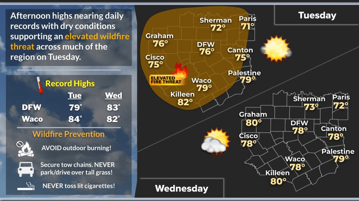
Good morning, and welcome to Tuesday. We are waking up to a mostly cloudy sky and unusually mild temperatures for this time of year, with readings only falling to the mid-to-upper 50s, approximately 20 degrees above average. We will see some sunshine today, accompanied by very warm conditions, with afternoon highs approaching 80 degrees, close to the record high of 79 degrees for today. Enjoy the weather while it lasts. Cedar fever will persist through the end of the week.
On Wednesday, we will wake up to a mostly clear sky with temperatures falling into the mid to upper 40s. Daytime highs will approach 80 degrees once again, with the record high for Wednesday being 83 degrees. Although we may not reach that record, temperatures will still be a significant 24 degrees above average.
A fast-moving storm system will pass through the northwestern third of the state on Thursday, bringing scattered showers to our area during the first half of the day, although the heaviest rain will fall in Oklahoma. We may receive up to a tenth of an inch of rainfall at the Fort Worth airport, and there is a slight chance of thunderstorms, but no severe weather is expected.
A cold front will move through the area late on Friday, bringing windy conditions and sharply colder temperatures. There will be an area of showers and storms forming along the cold front, but it appears that this area will be located just south and east of Dallas and Fort Worth. As the front passes, temperatures will plummet to the mid-to-upper 30s by Saturday morning, with wind chills in the upper 20s, which is around average for this time of year.
Sunny and breezy conditions will dominate on Saturday, with afternoon highs reaching the low to mid-50s and wind chills in the mid-to-upper 40s throughout the day. A light freeze is expected just north and west of the DFW area on Sunday morning, followed by sunny and beautiful conditions, with light winds and highs reaching the mid-to-upper 50s.
By Monday, a light freeze is expected, especially east of DFW, with highs returning to the low 60s, making it feel more like winter by the weekend.
Have a great day today and enjoy the weather when you can, it's the only weather you've got!
7-Day Headlines:
* DFW Airport reached 72 yesterday.
* Above average temperatures through Friday.
* Low chance of rain on Thursday. (< 0.25")
* Strong late Friday cold front.
* Colder this weekend, but dry.
* Light freeze in areas Sunday and Monday mornings.
* A slow warm up NEXT week.
*Yest Rain: 0.00"; Yest High: 72; Low: 47
*Today's Averages: High: 56; Low: 36
*Record high: 79 (1982); Record low: 11 (1912)
*January Rain: 0.00"; Deficit:
*2026 Rain: 0.00"; Deficit:
*Sunrise: 7:32am; Sunset: 5:38pm
Tuesday: Morning clouds, afternoon sun. A weak morning wind shift brings dry air. High: Mid to upper 70s. The record is 79 degrees. Wind: NW 5-10 mph.
Tuesday night: Mostly clear and cool. Low: Mid to upper 40s. Wind: Lt. Var.
Wednesday: Increasing clouds and warm. Near record high (83). High: Near 80. Wind: South 5-10 mph.
Thursday: Cloudy, breezy and mild. Scattered morning and early afternoon showers and isolated storms. Coverage at 30%. High: Mid 70s.
Friday: Mostly sunny and mild. High: Low 70s.
Saturday: Sunny, windy and colder. High: Low to mid 50s.
Sunday: Light morning freeze away from DFW. Sunny, less wind and cool. High: Mid to upper 50s.
Monday: Light morning freeze away from DFW. Sunny and beautiful. High: Low 60s.
LISTEN on the Audacy App
Tell your Smart Speaker to "PLAY 1080 KRLD"
Sign Up to receive our KRLD Insider Newsletter for more news
Follow us on Facebook | Twitter | Instagram | YouTube