Severe weather stays west of the Dallas-Fort Worth area today, just north of Dallas and Fort Worth tomorrow afternoon and evening, high temperatures in the 80s through Friday. A cold front brings showers to the area Saturday along with windy conditions and much cooler temperatures through Monday of next week.
Good morning my friends, welcome to Tuesday. We're waking up to low clouds once again and very warm temperatures for this time of the year. Readings are hovering near 70° with a south wind at 10 to 15 mph. Today will be partly cloudy, warm and breezy with highs reaching the mid 80s again. South winds will gust to 25 mph.
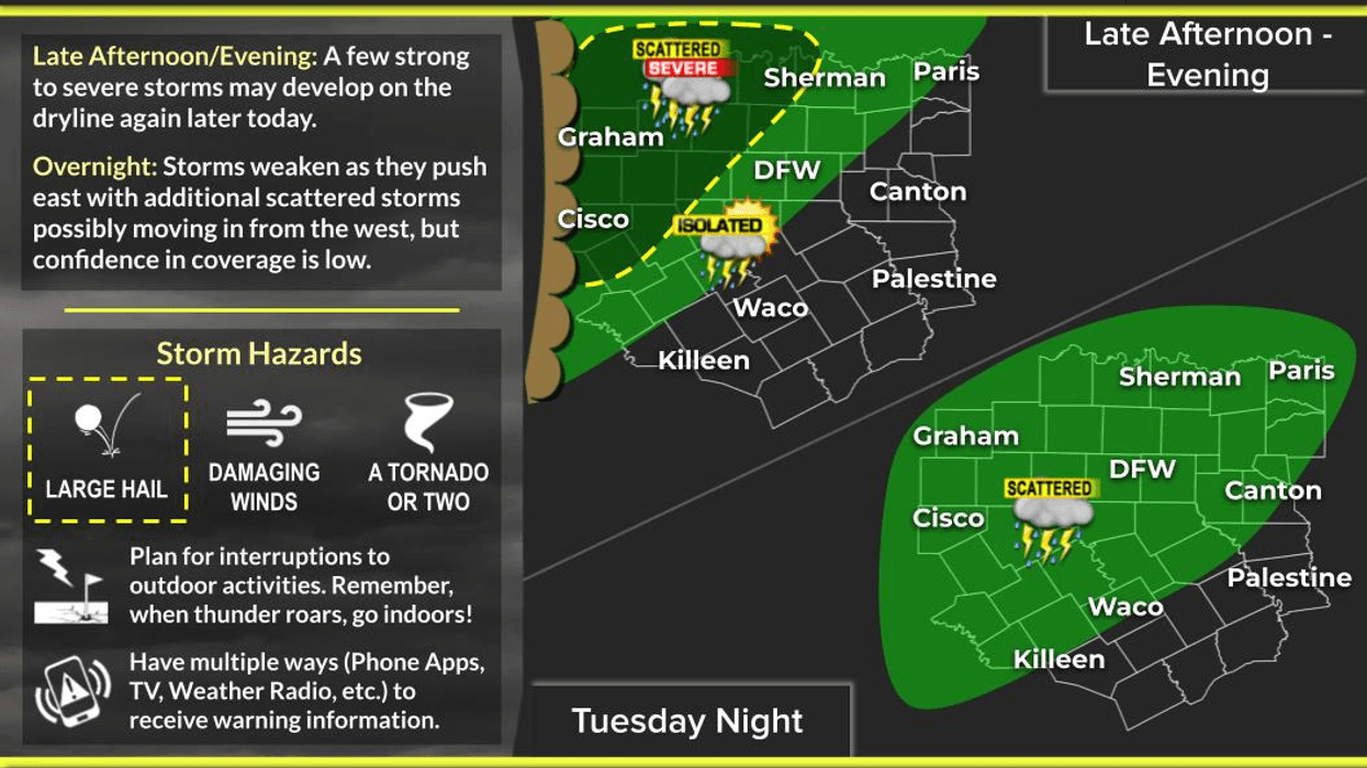
After 4:00 p.m., numerous supercells will form a couple of hundred miles to the west of Dallas and Fort Worth along the dryline. These storms will be shooting northeast mainly into Oklahoma, but areas just northwest of Fort Worth and Denton could see some severe weather before midnight tonight. Mainly along and northwest of a Gainesville to Weatherford to Comanche line. I am going to keep an eye on a cluster of storms forming along the Big Bend region of West Texas. These storms may survive and weaken as they approach north Texas by daybreak Wednesday. I'm not concerned about severe weather across North Texas overnight.
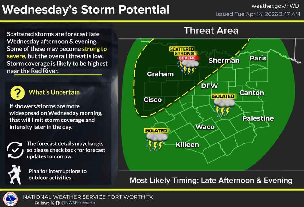
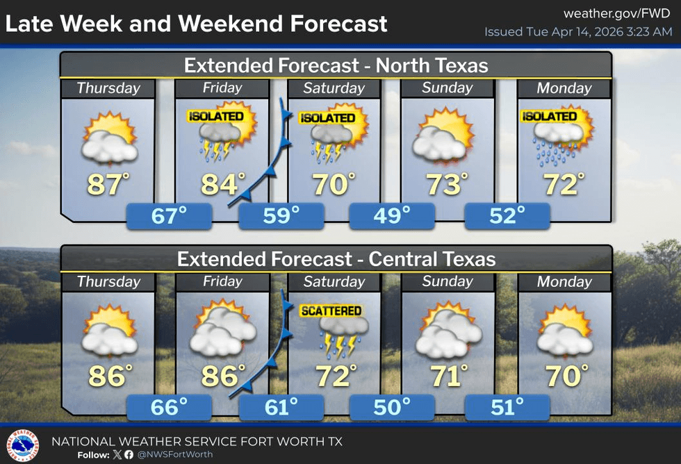
A few morning showers are possible Wednesday under a cloudy sky. Partly cloudy conditions will prevail Wednesday afternoon with high temperatures in the low 80s. There is a low chance of severe weather anywhere across North Texas but as of now, I think the greatest threat will be along and north of Highway 380 which runs between McKinney and Decatur. These storms will rapidly be moving Northeast into Oklahoma. All modes of severe weather are possible. As of now, it looks like the worst of it will be in southern Oklahoma. I'll keep an eye on things just in case.Thursday and Friday are relatively quiet. Morning low clouds and afternoon sunshine will prevail. Low temperatures will be near 70° with afternoon highs in the upper 80s on Thursday, mid 80s on Friday with very windy conditions.
Our next weather change arrives early Saturday morning in the form of a very strong cold front. This front will produce scattered showers and isolated thunderstorms during the morning on Saturday. Temperatures will hover near 70° and then rapidly fall into the mid fifties by mid-morning Saturday. North wind will gust to 30 mph, putting a little bit of a chill in the air. Sunshine will be slow to arrive by late afternoon as temperatures hover in the mid-60s.
Temperatures will fall into the mid to upper 40s on Sunday morning under a clear sky. Sunny and cool for the afternoon with high temperatures in the mid 60s. Clouds will increase Monday with a few showers possible. We'll struggle to get above 70°. Enjoy!
I'll keep an eye on the weather tomorrow, but I'm not overly concerned about a widespread severe weather outbreak across North Texas. Have a great day today and enjoy the weather when you can, it's the only weather you've got!
7-Day Headlines:
- DFW Airport reached 85 on Thursday.
- Above average temperatures through Friday. 80s!!
- A few showers today, not a big deal.
- Severe storms stay west this evening.
- A few Wednesday morning showers. Severe possible late day (north of DFW)
- Warm and dry Thursday and Friday.
- Early Saturday morning cold front brings BRIEF rain and MUCH cooler weather.
- Download our AUDACY app. Listen to KRLD at home!
Almanac:
- Yest Rain: 0.00”; Yest High: 85; Low: 68
- Today’s Averages: High: 76; Low: 54
- Record high: 91 (1951); Record low 35 (1959, 1997)
- April rain: 2.70”; Surplus: 1.43”
- 2026 Rain: 7.86”; Snow: 2.4” Deficit: <2.00”>
- Sunrise: 6:58am; Sunset: 7:58pm
- Tuesday: Morning clouds, afternoon sun. A few afternoon showers. Breezy and warm. High: Low to mid 80s. Wind: SE 15-25 mph.
- Tuesday night: Increasing clouds, breezy and mild. A slight chance of morning showers. Low: Near 70. Wind: South 15-25 mph.
- Wednesday: Morning clouds, afternoon sun. Scattered showers and storms late. Severe possible (mainly north of DFW). High: Low 80s. Wind: SE 15-25 mph.
- Thursday and Friday: Morning clouds, then partly cloudy, warm, and windy. High: Mid to upper 80s.
- Saturday: Morning cold front brings rain. Cloudy, windy and cooler. High: Low 70s early; Upper 50s at noon; 60s the rest of the day.
- Sunday: PERFECT! Sunny and cool. Low: 45-50; High: Low 70s.
- Monday: Increasing clouds and cool. Slight chance of showers. High: Upper 60s.