
Tuesday North Texas Weather Forecast
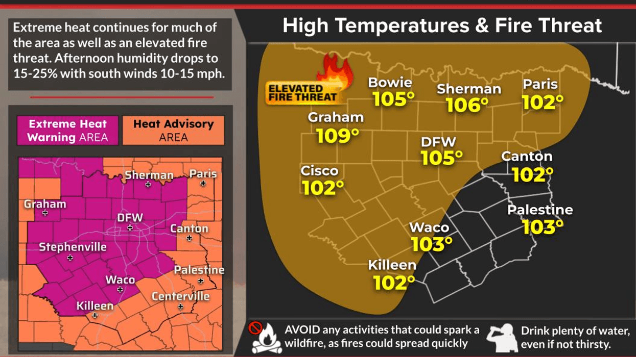
The brutal heat will continue today and tomorrow, although temperatures will be a little cooler than yesterday. We’ll see an even better break from the extreme heat beginning Thursday and continuing through the weekend, but temperatures will still linger around 100 degrees.
Good morning, everyone, and happy Tuesday. We’re waking up to temperatures in the 80s this morning under partly cloudy skies.
The rain I was hoping for, and talking about last night on my Facebook page, is mainly staying east of the Dallas-Fort Worth area. There could still be a few isolated showers developing across North Texas between now and 9 p.m., but chances look pretty slim.
The big weather stories today are the high grass fire danger, the continued heat warnings across North Texas, and our ongoing lack of rainfall. We’ve now gone 39 days without measurable rain at DFW Airport. August has been especially dry, with only a trace of rain measured so far this month.
By Wednesday, we may see a few scattered showers and thunderstorms as a weak cold front slides through the area. However, we desperately need more rain. August is typically one of the driest months of the year, and we’re certainly living up to that reputation this year.
I’m sure you’ve already heard about the dangerous Ross Grass Fire that started in Palo Pinto County yesterday. It has now spread into Jack County, with more than 25,000 acres burned and the fire only about 5% contained. Please remain extremely weather aware today. We have a high grass fire danger across all of North Texas, and burn bans are in effect for most counties.
As for temperatures, today will not be quite as hot as yesterday’s record-setting 109 degrees at DFW Airport. We’ll likely top out around 105 degrees, give or take a degree or two. Heat warnings remain in effect until 8 p.m. this evening.
Tomorrow, we’ll have a slight chance of a late-day or evening shower or thunderstorm as the weak cold front approaches, with a high around 102 degrees.
Thursday will be noticeably cooler, with plenty of sunshine and a high near 99 degrees. There could be a renegade shower or thunderstorm south of the Dallas-Fort Worth area.
Then, we’ll see plenty of sunshine and generally pleasant conditions Friday through the weekend, although highs will still be near 100 degrees. By the end of the month, our average daytime high drops to around 93 degrees, so cooler temperatures are coming eventually.
Again, stay weather aware because of the high grass fire danger. Stay hydrated, take frequent breaks if you’re working outdoors, and check on your pets, elderly neighbors, and those who may be especially vulnerable to the heat.
Stay cool, my friends, and enjoy the weather when you can; it's the only weather you’ve got!
7-Day Headlines:
- DFW Airport hit 109 degrees on Monday. NEW record!
- 30 triples this summer
- 39 days with no measurable rain at DFW
- HIGH GRASS FIRE DANGER!
- Heat Warnings continue
- Slight rain chance early Tuesday morning and Wednesday evening
- Weak Wednesday cold front. A tad cooler Thursday - the weekend
- Download our AUDACY app! Listen to KRLD LIVE at home or at work
Almanac:
- Yest Rain: 0.00”; Yest High: 109R; Low: 86R
- Today’s Averages: High: 94; Low: 75
- Record high: 110 (2023); Record low 61 (1926)
- August rain: Trace; Deficit: <1.56”>
- 2026 Rain: 22.61”; Snow: 2.4”; Deficit: <1.32”>
- Sunrise: 6:59am; Sunset: 8:00pm
Forecast:
Tuesday: **Extreme Heat Warning** Mostly sunny and hot. GRASS FIRE DANGER. High:105. Heat index:107. Record high: 110 (2023). Wind: SSW 10-20 mph.
Tuesday night: Passing clouds and warm. Slight chance for an overnight shower. Low: Low to mid 80s. Wind: South 10-20 mph.
Wednesday: **Possible Heat Advisory** Partly cloudy and hot. Afternoon WEAK cold front brings a slight chance of rain with it. Most stay dry. High: 102. The record is 110 (2023). Wind: South to north 5-10 mph.
Thursday: Partly cloudy, not as hot. Low humidity. High: Upper 90s.
Friday: Mostly sunny and hot. High: Near 100.
Weekend: Mostly sunny, breezy and hot. Grass fire danger returns! High: 102.
Monday: Mostly sunny, breezy and hot. Grass fire danger! High: 103.
LISTEN on the Audacy App
Tell your Smart Speaker to "PLAY 1080 KRLD"
Sign Up to receive our KRLD Insider Newsletter for more news
Follow us on Facebook | Twitter | Instagram | YouTube