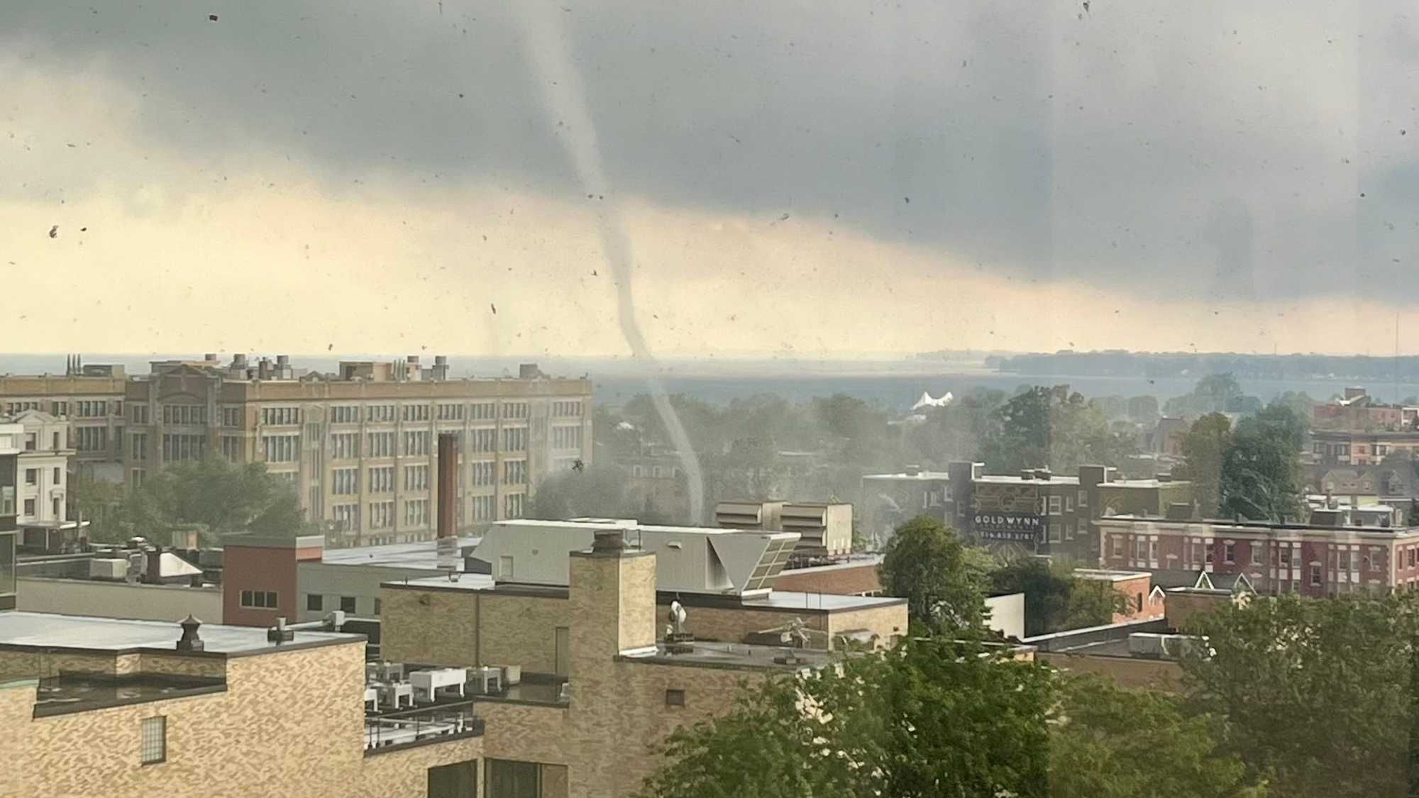
Buffalo, N.Y. (WBEN) - Residents and officials in Buffalo are still in shock after an EF-1 tornado suddenly touched down on Monday and cut a 1.4 mile path though the city, leaving behind a path of damage in the Lower West Side neighborhood.
The storm that produced the tornado in Buffalo just before 1 p.m. ET on Monday moved its way across Fort Erie, Ontario and the mouth of the Niagara River, and eventually continued with enough strength to drop a narrow, but powerful vortex the topped several trees, and even caused some roofing damage to buildings and cars in other parts of the city.
"As it hopped the 190, for a period of about 4-to-6 minutes, it narrowed in the vortex. So the vortex, instead of being as wide as the river, it was only maybe half a city block, if that. And then it began to intensify in the winds around that, what you'd call a drill bit tornado or vortex, that drill bit caused the damage path. That's why it was only, really, a couple of streets downtown, because it wasn't a wide swath. It became very narrow, but that narrowing made it more intense. That's when those winds reached EF-1 or 90 miles an hour, and snapped some poles and toppled trees and tipped a few cars," said meteorologist Andy Parker while appearing with David Bellavia on Tuesday.
Ahead of most storms that could produce tornados, including the storms that swept through Western New York back on July 10 with the remnants of Hurricane Beryl, the National Weather Service will issue a Tornado Watch or Warning, depending on the conditions that are present or developing with a system.
When the tornado struck the city on Monday, there was little-to-no warning for forecasters and meteorologists to be able to issue a Tornado Warning, advising residents and others in the affected areas to take cover.
"Our weather radar is a life-saving tool, but it has its limits. In this case, it did not pick up on the tornado for the forecasters to see," said National Weather Service meteorologist Heather Kenyon in an interview with WBEN. "We do have our trained Skywarn spotters, the public, the media out there to kind of be the eyes and ears on the ground. That's such a critical part in the warning process for us, because of some of the tools that have limitations. We continue to express our gratitude to the spotters, and especially with the City of Buffalo, with the population, we were getting videos almost in real time to see that quick spin up that happened in the city."
Some storms that have the potential to produce tornados are easier targets to hit with the radar, but Parker says this particular tornado, the way it developed, there were not many warning signs or indications that this storm was going to produce this vortex.
"It's not up in the sky, it didn't develop over an hour and then come down. It was a very fast, matter of minutes for this to develop and drop. So I think the radar being at the airport, the fact this was a very low end [tornado], it wasn't a big EF-3 that was a mile wide, this thing was extremely narrow as it developed. It's very tough to pick out of the clutter on the radar, so that's why I think this went unwarned in the area," Parker explained on WBEN.
Kenyon adds this type of tornado was very unique to the region.
"We don't often see tornados forming and moving into the City of Buffalo. This specific circulation, after talking to Environment Canada, actually formed to our West and tracked into the City of Buffalo. But again, because of the limitations of our radar, it did not pick up on that," Kenyon said. "Our mission is to protect lives and property, and using the tools of social media and the public to help us out when warning is such a critical part."
This latest tornado to strike Buffalo on Monday adds to an already record-breaking year for not just the region, but also New York State.
"We've hit our record number of tornados for the state, as well as for our forecast area. This year, it will go down as a record number for tornados," Kenyon said. "We've had a couple strong weather systems, the first being post-Tropical Storm Beryl that moved through in July, the July 10 event, where it spun up a couple tornadoes just Southeast of Buffalo. And then we had a system move through a couple weeks later. It has been a year, definitely, for the records."
Part of the reason why Parker believes there's more tornados being recorded in the state than ever before is due to more observation from the community, which includes those who post tornados such as Monday's storm on social media.
However, trying to forecast a given season for tornados, especially for Western New York, is no easy task.
"It's very difficult to say that far in advance," Parker said. "When you think about the hurricane, the remnants of that that came up here and that's what set off that string of tornadoes, if you don't have the remnants of that hurricane come up, we're kind of in an average year. It's really those random events that come up and trigger an unusual result. Those are the things that you can't really predict and say, 'Hey, the remnants of a hurricane are going to roll up and it's going to happen in just a particular time and place that we're going to end up with three or four tornadoes out of it.' You just can't foresee that happening. So long range tornado stuff in New York is tough."
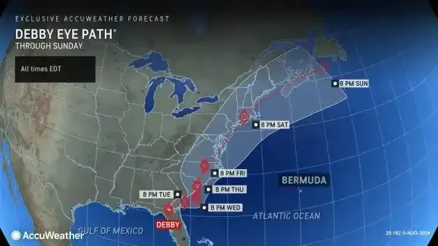
Heading into the rest of the week, a lot of the attention will be along the East Coast with Tropical Storm Debby potential wreaking havoc after it is expected to move back over water for a brief time before moving back inland as it rides up areas like the Carolinas and up through the Northeast.
While the potential threat of tornados remains low locally, the focus at hand in the coming days will be for the threat of heavy rainfall.
"It does look like some moisture is going to move into New York State. There's a great deal of uncertainty right now where the rainfall will be, it does look like it would mainly be the Finger Lakes region to the East. However, areas across Western New York, people should be watching the weather, because this would be for Friday, Friday night, there is a low chance of some heavy rainfall for the area," said Kenyon.