
Buffalo, N.Y. (WBEN) - More snow is in the forecast, this time for metro Buffalo, as a new weather system will move southeast across the lower Great Lakes Monday and Monday night, setting the stage for one last round of localized moderate to heavy lake snows
A band of lake enhanced snow will form and then move north to the Buffalo metro area from late morning through this evening. The band of snow will likely broaden out over a larger footprint for several hours this afternoon, National Weather Service forecasters say.
A Winter Weather Advisory has now been posted for the metro Buffalo area, all of Erie, Niagara, Orleans, Genesee and Wyoming counties.
The Monday evening commute is likely when snow will be most persistent, potentially causing traffic delays and poor road conditions in spots at times.

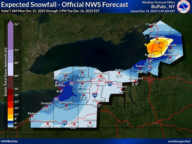
As far as accumulations go, expect a general 2-4" in the area of lake enhancement across the Niagara Frontier, with some local 5" reports possible where the lake snow lasts the longest.

Midweek Warmup
A strong cold front will then cross the eastern Great Lakes Thursday night, bringing strong, gusty winds and a period of rain. Much colder air will pour back into the region Friday with lake effect snow showers.
WINTER WEATHER ADVISORY REMAINS IN EFFECT FROM 10 AM THIS MORNING TO 7 AM EST TUESDAY
* WHAT...Lake effect snow expected. Total snow accumulations 2 to 5 inches in the most persistent lake snows.
* WHERE...Niagara, Orleans, Northern Erie, and Genesee Counties. The greatest accumulations will be across the Buffalo Metro area, southern Niagara, southwest Orleans, and western Genesee counties.
* WHEN...From 10 AM this morning to 7 AM EST Tuesday.
* IMPACTS...Plan on snow covered and slippery road conditions with reduced visibility. The hazardous conditions will impact the Monday evening commute.
PRECAUTIONARY/PREPAREDNESS ACTIONS...
Lake effect snow will fall in relatively narrow bands. If traveling, be prepared for rapidly changing road conditions and visibilities.
WINTER WEATHER ADVISORY REMAINS IN EFFECT FROM 10 AM THIS MORNING TO 7 AM EST TUESDAY
* WHAT...Lake effect snow expected. Total snow accumulations 2 to 5 inches in the most persistent lake snows.
* WHERE...Wyoming and Southern Erie Counties. The greatest accumulations will be from southern Erie County to the ridges of western Wyoming County.
* WHEN...From 10 AM this morning to 7 AM EST Tuesday.
* IMPACTS...Plan on snow covered and slippery road conditions with reduced visibility. The hazardous conditions will impact the Monday evening commute.
PRECAUTIONARY/PREPAREDNESS ACTIONS...
Lake effect snow will fall in relatively narrow bands. If traveling, be prepared for rapidly changing road conditions and visibilities.