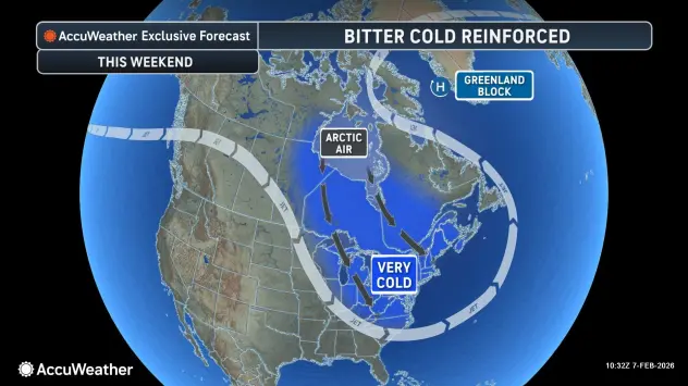

Buffalo, N.Y. (WBEN) - The coldest weekend of the winter season is upon us.
Dangerously cold wind chills between 15 and 35 below zero are expected this weekend after an arctic front crossed into the region Friday night, bringing with it subzero temperatures and windy conditions.
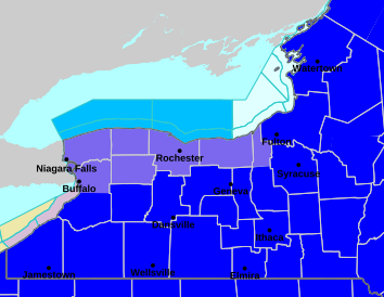
A Cold Weather Advisory remains in place for the Buffalo metro area and northern portions of WNY, while an Extreme Cold Warning is in place for southern Erie County and the southern tier.
The difference in 'how cold' it is between the advisory area and warning area is negligible as far as how things will feel across the region for the weekend.
"Areas of the Extreme Cold Warning will be a little bit colder, with wind chills down to minus 30...for areas in the Cold Weather Advisory, wind chill values down to minus 15 to 24, National Weather Service meteorologist Steven Welch tells WBEN"
The cold weather this weekend is among the coldest ever for February in WNY, possibly rivaling that of February 2016.
Winds will diminish across the region Saturday night through Sunday, but a still plenty cold airmass with sub zero air temperature readings will promote wind chill values in the negative double digits for our region through Sunday late morning.
Some lake effect snow is still lingering, with a Winter Weather Advisory for most of the area Saturday.
"That lake effect snow is going to continue today, and combined with gusty winds, is going to produce blowing and drifting snow and reduced visibility.
Any relief in sight?
NWS meteorologist Heather Kenyon tells us we do remain on the cooler side through next week, but with some moderation, especially after this weekend.
"We are going to get 'warmer', with temperatures just slowly climbing up to near normal, which is about the freezing mark" Kenyon says.
WINTER WEATHER ADVISORY REMAINS IN EFFECT UNTIL 7 PM EST THIS EVENING
* WHAT...Localized lake effect snow. Additional snow accumulations 1 to 3 inches expected, with locally higher amounts possible across the hilltops south of Buffalo and across Orleans County. Lower-end amounts expected from the city of Buffalo to Niagara Falls. Winds gusting as high as 40 mph will create areas of blowing and drifting snow with poor visibilities at times.
* WHERE...Erie, Niagara, Orleans, Genesee, Wyoming, Chautauqua, and Cattaraugus Counties.
* WHEN...Until 7 PM EST this evening.
* IMPACTS...Plan on slippery road conditions and reduced visibilities.
PRECAUTIONARY/PREPAREDNESS ACTIONS...
Periods of snow will result in snow covered roads and limited visibilities. Slow down and use caution while driving.
COLD WEATHER ADVISORY REMAINS IN EFFECT UNTIL 10 AM EST SUNDAY
* WHAT...Bitterly cold wind chills between 15 and 24 below zero expected. The coldest wind chills are expected to be today.
* WHERE...Niagara, Orleans, Monroe, Wayne, Northern Cayuga, Northern Erie, and Genesee Counties.
* WHEN...Until 10 AM EST Sunday.
* IMPACTS...Bitterly cold wind chills as low as 25 below zero will cause frostbite on exposed skin in as little as 15 minutes.
PRECAUTIONARY/PREPAREDNESS ACTIONS...
This is a potentially hazardous situation to be outdoors. If you must be outside, be sure to cover all exposed skin. Frostbite can occur in 30 minutes or less with apparent temperatures of 15 below zero or colder.
EXTREME COLD WARNING REMAINS IN EFFECT UNTIL 10 AM EST SUNDAY
* WHAT...Dangerously cold wind chills as low as 30 below zero expected. The coldest wind chills are expected to be today.
* WHERE...Wyoming, Livingston, Ontario, Chautauqua, Cattaraugus, Allegany, and Southern Erie Counties.
* WHEN...Until 10 AM EST Sunday.
* IMPACTS...Dangerously cold wind chills as low as 30 below zero will cause frostbite on exposed skin in as little as 15 minutes.
PRECAUTIONARY/PREPAREDNESS ACTIONS...
This is a potentially dangerous situation to be outdoors. If you must be outside, be sure to cover all exposed skin. Frostbite can occur in 15 minutes or less with apparent temperatures of 25 below zero or colder.