
Buffalo. N.Y. (WBEN) - Lake effect snow pummeled the Buffalo southtowns Monday night, leading to near impossible driving conditions in some locations and numerous school districts making the decision to close Tuesday.
CHECK: WBEN Closings
A Winter Storm Warning remains posted for metro Buffalo and much of WNY, through Wednesday. A Cold Weather Advisory is posted for the southern tier as wind chills may reach 20 below zero.
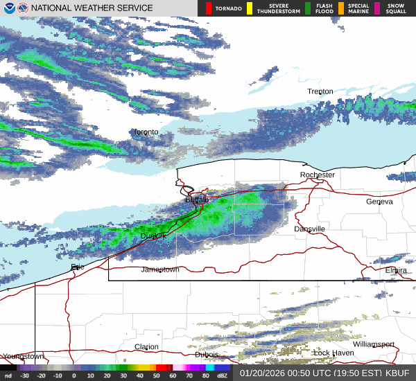
"It came through about twice as fast as what the computer models were expecting," 'Ask Andy meteorologist Andy Parker tells WBEN. The lake snow band that was living around Lewiston and across Niagara County through Monday morning, was given a big push by gusty winds during the midday hours and made a quick pass across the metro area and into the southtowns.
The snow band was enough to force officials to close the Buffalo Skyway due to the poor weather conditions.
Lake effect snow will now become 'stuck' in the southtowns, Parker says."It's going to take a diagonal that runs along the lakeshore from Ripley, Westfield, Dunkirk, Silver Creek, Angola, and then it's going to come inland just south of Blasdell, and that will include Orchard Park, Hamburg, Elma, Marilla, out to Attica," Parker forecasts. "It's going to live bwteen Orchard Park and Springville."
The traditional southtowns snowbelt will be the target late Monday and into Tuesday with the potential for 1 to 2 feet of accumulation in spots. The snow band will lift northward and weaken late Tuesday and into Wednesday, Parker notes.
As for what to expect Tuesday and possible school closures resulting from the weather? "I would expect to see some school closings, especially in the southtowns," Parkers says.
The Lake Erie ice cover has been in the 30-percent range, Parker tells us. And he expects that to increase to 50-percent by week's end, given the colder conditions.

Windy and Cold
As problematic as the snow will be the gusty winds and cold temperatures, forecasters caution.
"Very windy today, especially this(Monday) afternoon," National Weather Service meteorologist Tony Ansuini tells WBEN. "The winds may actually be more impactful than the actual snowfall amounts."
Wind gusts of 40 to 50 mph will cause very hazardous and difficult driving conditions whit whiteout conditions at times.
And then there is the frigid cold temperatures that are hunkering down with the weather systen.
"Dangerously cold tonight, especially tonight," Ansuini emphasizes. "Wind chills of 10 below, to 20 below zero, with the coldest wind chills probably across the western southern tier."
Related

We're not done yet!
"It looks like we have even colder air that's going to settle in for the end fo the week and into the weekend," Ansuini cautions. "Looking for daytime highs only in the teens at best, and overnight low temperatures of zero or even colder."
Stay tuned to NewsRadio 930 WBEN for the latest forecast details and check back here for the latest on-demand.
WINTER STORM WARNING REMAINS IN EFFECT UNTIL 4 PM EST WEDNESDAY
* WHAT...Heavy lake effect snow. Additional snow accumulations 10 to 18 inches in the most persistent bands. Winds gusting as high as 50 mph will produce significant blowing and drifting snow and near whiteouts at times. Snowfall rates may reach 2 to 3 inches per hour at times in the strongest lake effect snow bands.
* WHERE...Northern Erie and Genesee Counties. The greatest additional accumulations will be across the Buffalo Southtowns and southern Genesee County.
* WHEN...Until 4 PM EST Wednesday.
* IMPACTS...Whiteout conditions are expected and will make travel treacherous and potentially life-threatening. Roads, and especially bridges and overpasses, will likely become slick and hazardous. Travel will be very difficult. The hazardous conditions will impact the Monday evening and Tuesday morning commutes.
PRECAUTIONARY/PREPAREDNESS ACTIONS...
Heavy lake effect snow will create dangerous travel conditions.
WINTER STORM WARNING REMAINS IN EFFECT UNTIL 3 PM EST WEDNESDAY
* WHAT...Heavy lake effect snow. Additional snow accumulations 12 to 20 inches, with localized amounts of 2 to 3 feet across southwest and central Erie County in the most persistent bands. Winds gusting as high as 45 mph will produce significant lake effect snow and near whiteouts at times. Snowfall rates of 2 to 3 inches per hour in the most intense band.
* WHERE...Wyoming, Chautauqua, Cattaraugus, and Southern Erie Counties. Greatest snow accumulation across central and southern Erie County, western Wyoming County, extreme northern Chautauqua County, and extreme northwest Cattaraugus County.
* WHEN...Until 3 PM EST Wednesday.
* IMPACTS...Whiteout conditions are expected and will make travel treacherous and potentially life-threatening. Travel will be very difficult in deep snow covered roads. Areas of blowing snow will significantly reduce visibility. The hazardous conditions will impact the Monday evening through the Wednesday morning commutes.
Gusty winds will down tree branches and cause isolated power outages.
PRECAUTIONARY/PREPAREDNESS ACTIONS...
Widespread accumulating snow will create dangerous travel conditions.
COLD WEATHER ADVISORY REMAINS IN EFFECT FROM 10 PM THIS EVENING TO 1 PM EST TUESDAY
* WHAT...Bitterly cold wind chills as low as 20 below zero possible.
* WHERE...Wyoming, Chautauqua, Cattaraugus, and Allegany Counties.
* WHEN...From 10 PM this evening to 1 PM EST Tuesday.
* IMPACTS...Bitterly cold wind chills as low as 20 below zero will cause frostbite on exposed skin in as little as 30 minutes.
PRECAUTIONARY/PREPAREDNESS ACTIONS...
This is a potentially hazardous situation to be outdoors. If you must be outside, be sure to cover all exposed skin. Frostbite can occur in 30 minutes or less with apparent temperatures of 15 below zero or colder.