
Buffalo, N.Y. (WBEN) - The timing will be everything when it comes to an anticipated lake effect snow system that develops initially across the metro Buffalo area late Wednesday, then moves southward and settles into the southern tier for Thanksgiving Day.
The key questions to be answered, National Weather Service forecasters say, are where the initial snow band sets up and how long it remains before settling southward.
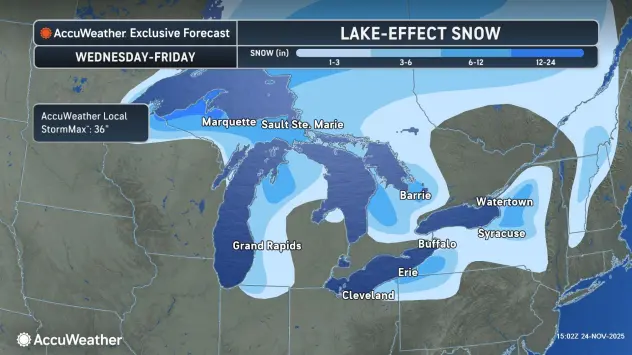
What is known, is a powerful cold front will enter the region Wednesday, ushering in gusty winds and localized heavy lake effect snow east of the lakes Wednesday night through the end of the week.
A number of advisories are posted for the region beginning late Wednesday:
A Winter Weather Advisory for northern Erie, Niagara, Orleans and Genesee counties.
A Wind Advisory for the Buffalo metro and most of WNY midday Wednesday through Thursday.
A Lake Effect Snow Warning for southern Erie, Wyoming, Chautauqua and Cattaraugus counties from midday Wednesday through Thursday.
Mild conditions will prevail through much of Wednesday, before a cold front rushes through and ushers in big changes.
When will rain change to snow Wednesday?
"It looks to me like it's going to happen in that Wednesday evening timeframe," NWS meteorologist Tom Niziol tells WBEN. "Probably sometime after the rush hour."
Is metro Buffalo off the hook with this one?
"It's not quite off the hook...we've got to take a good look at that and keep an eye one it," NWS meteorologist Aaron Reynolds cautions. "It will depend on how fast that band moves through the Buffalo metro area. If it slows down, there could be more. If it speeds up, there could be considerably less."
Turkey Trot?
"If you're preparing for the Turkey Trot, prepare for the worst," Niziol advises. He says the current models show the lake effect band south of the Buffalo metro area at the time of the race, however that could change, and runners and spectators should be prepared.
Southern tier bullseye
It does appear the southern tier will ultimately be the bullseye of this lake effect event. "We're looking for a major event here," Niziol cautions, saying the snow combined with strong winds gusting to 50 mph will make travel in that area difficult. As much as 12 to 20 inches of snow could accumulate across portions of the southern tier where the lake effect bands target.
Before the lake effect arrives, Western New York will contend with some milder temperatures Tuesday and some light rain across the region.
Everything changes when the cold front roars in with gusty winds later in the day Wednesday and the lake effect machine sets up.
More to come!
WINTER WEATHER ADVISORY IN EFFECT FROM 9 PM WEDNESDAY TO 1 PM EST THURSDAY
* WHAT...Lake effect snow expected. Total snow accumulations 2 to 5 inches in the most persistent lake snows. Winds gusting as high as 50 mph will produce blowing and drifting snow.
* WHERE...Northern Erie and Genesee Counties.
* WHEN...From 9 PM Wednesday to 1 PM EST Thursday.
* IMPACTS...Plan on slushy and slippery road conditions. The hazardous conditions will impact Thanksgiving holiday travel.
Gusty winds will down tree branches and cause isolated power outages.
PRECAUTIONARY/PREPAREDNESS ACTIONS...
Lake effect snow will fall in relatively narrow bands. If traveling, be prepared for rapidly changing road conditions and visibilities.
WINTER WEATHER ADVISORY IN EFFECT FROM 7 PM WEDNESDAY TO 7 AM EST THURSDAY
* WHAT...Lake effect snow expected. Total snow accumulations 2 to 4 inches in the most persistent lake snows. Winds gusting as high as 50 mph will produce blowing and drifting snow.
* WHERE...Niagara and Orleans Counties.
* WHEN...From 7 PM Wednesday to 7 AM EST Thursday.
* IMPACTS...Plan on slushy and slippery road conditions. The hazardous conditions will impact Thanksgiving holiday travel.
Gusty winds will down tree branches and cause isolated power outages.
PRECAUTIONARY/PREPAREDNESS ACTIONS...
Lake effect snow will fall in relatively narrow bands. If traveling, be prepared for rapidly changing road conditions and visibilities.
WIND ADVISORY IN EFFECT FROM NOON WEDNESDAY TO 1 AM EST FRIDAY
* WHAT...Southwest winds 30 to 40 mph with gusts of 50 to 55 mph expected Wednesday afternoon and Wednesday night. West winds 25 to 35 mph with gusts of 45 to 50 mph expected Thursday through Thursday night.
* WHERE...Erie, Niagara, Orleans, Genesee, Wyoming, and Chautauqua Counties.
* WHEN...From noon Wednesday to 1 AM EST Friday.
* IMPACTS...Gusty winds will blow around unsecured objects. Tree limbs could be blown down and a few isolated power outages may result.
PRECAUTIONARY/PREPAREDNESS ACTIONS...
Use extra caution when driving, especially if operating a high profile vehicle. Secure outdoor objects.
LAKE EFFECT SNOW WARNING IN EFFECT FROM 1 AM THURSDAY TO 1 AM EST SATURDAY
* WHAT...Heavy lake effect snow expected. Total snow accumulations 12 to 20 inches in the most persistent lake snows. Winds gusting as high as 50 mph will produce blowing and drifting snow.
* WHERE...Wyoming, Chautauqua, Cattaraugus, and Southern Erie Counties.
* WHEN...From 1 AM Thursday to 1 AM EST Saturday.
* IMPACTS...Travel will be very difficult with deep snow cover on roads and poor visibility. The hazardous conditions will impact Thanksgiving holiday travel. Gusty winds will down tree branches and cause isolated power outages.
PRECAUTIONARY/PREPAREDNESS ACTIONS...
Heavy snow will fall in relatively narrow bands. If traveling, be prepared for rapidly changing road conditions and visibilities.