Here we go again, black ice has formed across North Texas, and as we are all aware, secondary roads and subdivision roads have become an icy mass. All schools are closed again across North Texas.
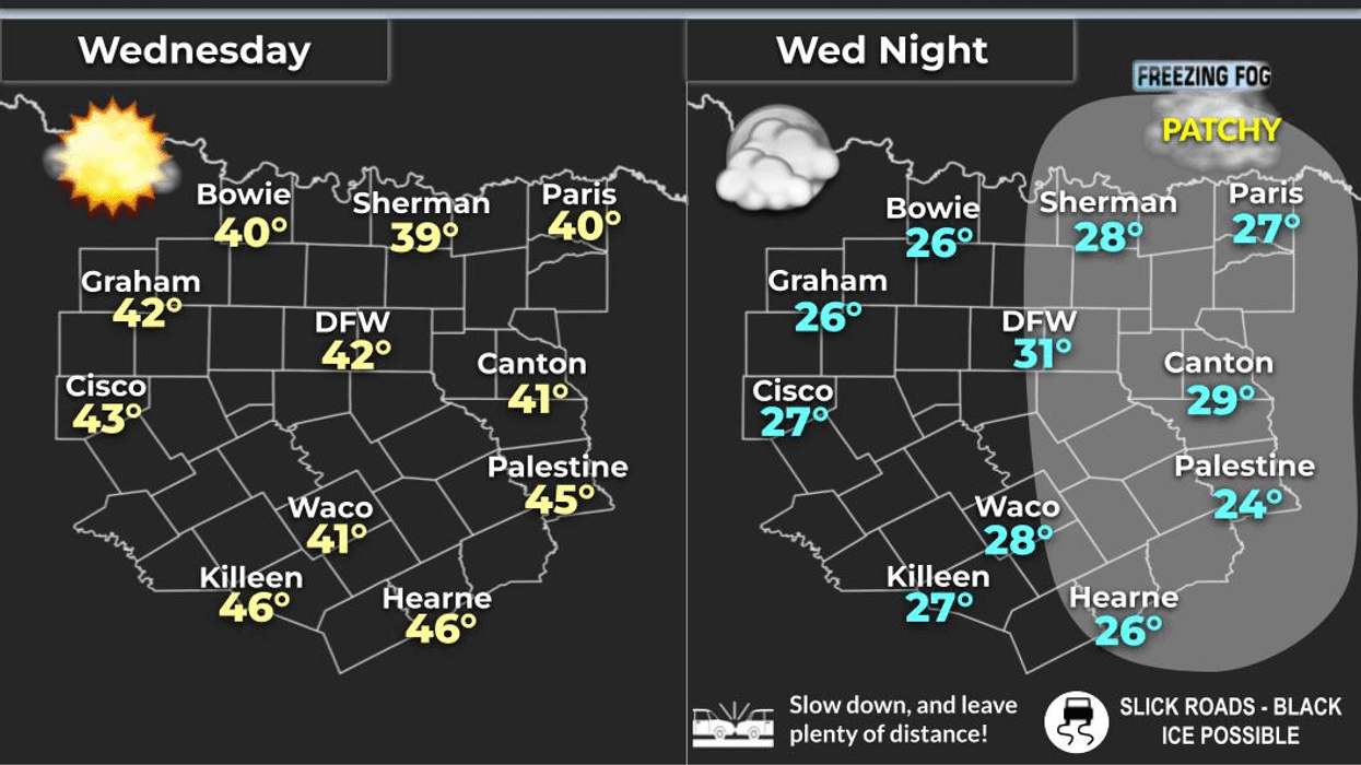
Good morning, my friends and followers, and welcome to what I believe is Wednesday. We are waking up to temperatures in the mid-20s, and a freezing fog advisory is in effect until 9:00. While many areas have not experienced fog this morning, some areas have, so it will sneak up on you quickly. If you must venture out, please allow extra time to reach your destinations and keep your speeds down.
We will safely be above freezing after 9:00 a.m. and reach the low 40s later today. However, this will not significantly impact the interior roads and especially roads in your neighborhoods, which will remain very icy and slick.
Tonight will not be as cold, with many areas staying slightly above freezing under a partly cloudy sky. Unfortunately, the interior roads and especially the roads in your subdivision will remain very slick. Tomorrow will be warmer, with highs reaching the low to mid-50s, which will help slush up the roads in your subdivision as well as the secondary roads. The highways will dry out and be fine.
A cold front will move through the area by late afternoon, but the air behind it will not be that cold, chilling temperatures down into the upper 20s for Friday morning, with highs reaching the mid-40s.
Unfortunately, another Arctic blast will arrive while you are sleeping into Saturday morning. Temperatures will plummet, and by daybreak, will range anywhere between 18° and 22°, with wind chills in the single digits. Unfortunately, many neighborhood roads will remain ice-packed through the weekend. We will struggle to get above freezing, with wind chills in the 20s all day Saturday.
On a positive note, at least the sun will be out, and no precipitation will fall behind this Arctic boundary. On Sunday morning, temperatures will be in the low 20s, and plenty of sunshine during the day will warm us up into the low 40s.
Our warm-up will continue on Monday, with highs in the low 50s, and by Tuesday, temperatures will be near 60°, which should eliminate all the ice in your neighborhoods.
It has been quite a storm, and I know everyone has cabin fever and is ready to get out. If you must venture out, travel after the noon hour and take it slow, especially when getting out of your subdivisions. Also, please be sure to start dripping your faucets before you go to bed on Friday, and you can stop doing this by Monday afternoon.
Please share this forecast discussion with your friends, family, and coworkers. I would greatly appreciate it. Oh, and thank you for listening to NewsRadio 1080 KRLD AM, DFW's number one station for severe weather coverage.
7-Day Headlines:
* DFW Airport reached 42 yesterday.
* Freezing Fog Advisory until 9am.
* Black ice, sleet packed and cobble stone ice this morning.
* Back above freezing by 10am today.
* A brief warm up through Thursday.
* Another Arctic cold front Friday, no precipitation.
* A COLD weekend to come.
* Scattered Ice, in areas, will linger through the weekend.
*Yest Rain: 0.00"; Yest High: 42; Low: 19
*Today's Averages: High: 58; Low: 37
*Record high: 85 (1903); Record low: 11 (1948)
*Yesterday rain: 0.00"; Deficit:
*2026 Rain: 0.93"; Snow: 2.4" Deficit:
*Sunrise: 7:26am; Sunset: 5:58pm
Wednesday: **Freezing Fog Advisory ends at 9am** Sunny and chilly. Ice sticks around in areas. High: Low 40s. Wind: North 5 mph.
Wednesday night: High clouds, not as cold. Low: Near 30. Wind: South 5-10 mph.
Thursday: High clouds, breezy and cool. Low: Near 30; High: Mid 50s. Wind: South to North 10-20 mph.
Friday: Partly cloudy and cool. Low: Near 30; High: Low Mid to upper 40s.
Saturday: Early morning ARCTIC front. Partly cloudy, windy and cold. Low: 18-22; High: Low 30s.
Sunday: Sunny, less wind. Low: Low to mid 20s; High: Low 40s.
Monday: Sunny, windy and warmer. A south wind returns. High: Mid 50s.
Tuesday: Increasing clouds and perfect. High: Near 60.
LISTEN on the Audacy App
Tell your Smart Speaker to "PLAY 1080 KRLD"
Sign Up to receive our KRLD Insider Newsletter for more news
Follow us on Facebook | Twitter | Instagram | YouTube