I'm still trying to determine the day of the week, but it appears to be Friday. LOL. A mild start this morning and these mild temperatures will continue through the weekend, with even warmer temperatures anticipated through the middle of next week, which will undoubtedly be a welcome development.
Good morning, and welcome to Friday. We are experiencing very mild temperatures for this time of year, with readings in the 50s being enjoyed by everyone. Typically, we would expect temperatures in the mid-30s at this time of year.
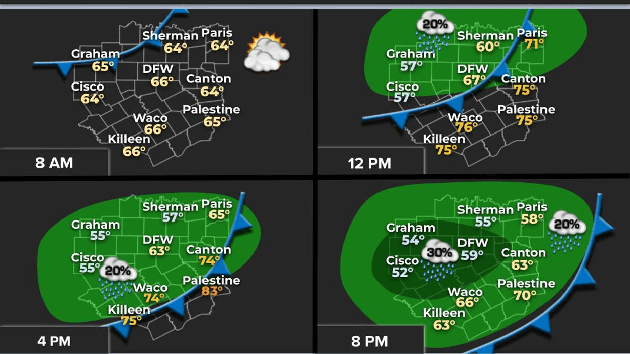
I am tracking a weak windshift moving in from the northwest, which will arrive after lunchtime, shifting winds from south to north at 5 to 10 miles per hour. Highs will reach the low 70s, just like yesterday! There is no cold air or precipitation expected with this front, and it will only slightly cool temperatures down over the weekend.
On Saturday morning, temperatures will range from 45° to 50° with a light north wind. It will be sunny and beautiful on Saturday, with highs slightly cooler than today, reaching the mid-60s, approximately 10° above average for this time of year. Most areas will experience temperatures in the mid-to-upper 40s on Sunday morning, with afternoon highs reaching the upper 60s.
A high-pressure system in the upper levels of the atmosphere will build over the area through the middle of next week, allowing temperatures to rise even further. I anticipate mid-70s on Monday with plenty of sunshine.
Passing high clouds are expected on Tuesday, with a near-record high anticipated. The record for the day is 79°, and I am predicting 80° at this time.
The subtropical jet stream, which is typically active this time of year, has been inactive. It will finally bring a weak system across the state on Wednesday into Thursday, increasing clouds on Wednesday and bringing a slight chance of rain late Wednesday into Thursday morning. It is still too early to determine if thunderstorms will develop, but severe weather is not anticipated at this time. Clouds on Wednesday will keep temperatures down a few degrees, reaching the mid-to-upper 70s. Thursday will bring morning showers and afternoon sun, with highs in the low 70s.
As of now, it appears that a stronger cold front will drop temperatures to near seasonal averages by the end of next week, but nothing excessively cold is expected.
Have a great day today, an awesome weekend, and please enjoy the weather when you can, as it is the only weather you've got!
7-Day Headlines:
* DFW Airport reached 71 yesterday.
* A mild start to Friday morning.
* A weak Friday afternoon cold front.
* A beautiful weekend ahead!
* A mild start to the New Year.
* Next week is warm, possible record high on Tuesday.
* Slight rain chance late Wednesday into Thursday.
*Yest Rain: 0.00"; Yest High: 71; Low: 42
*Today's Averages: High: 56; Low: 36
*Record high: 78 (2004, 2023); Record low: 8 (1911)
*January Rain: 0.00"; Deficit:
*2025 Rain: 0.00"; Deficit:
*Sunrise: 7:31am; Sunset: 5:34pm
Friday: Mostly sunny and beautiful. Afternoon weak cold front. High: Low 70s. Wind: South to North 5-10 mph.
Friday night: Clear and cool. Low: 45-50. Wind: NNW 5-10 mph.
Saturday: Sunny and pleasant. High: Mid 60s. Wind: North 5-10 mph.
Sunday: Passing high clouds and mild. High: Upper 60s.
Monday: Passing high clouds and mild. High: Low: Mid 70s.
Tuesday: Mostly sunny and warm. Near record highs (79). High: Near 80.
Wednesday: Increasing clouds and pleasant. Slight rain chance towards evening. High: Upper 70s.
Thursday: Morning showers, then decreasing clouds and comfortable. High: Low 70s.
LISTEN on the Audacy App
Tell your Smart Speaker to "PLAY 1080 KRLD"
Sign Up to receive our KRLD Insider Newsletter for more news
Follow us on Facebook | Twitter | Instagram | YouTube