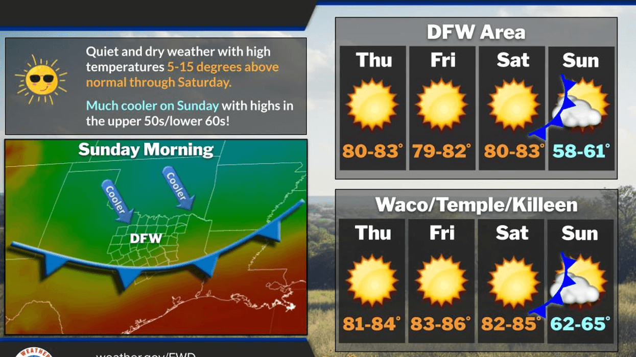
A warm and dry weather pattern will persist through Saturday, but a significant change is anticipated late Saturday night, lasting through next Tuesday morning. Unfortunately, no precipitation is forecasted over the next seven days.
Good morning, ladies and gentlemen. I hope your Tuesday was pleasant. As mentioned earlier, a substantial weather change is expected this weekend, so ensure your warmer jackets are readily available and your chimneys are cleaned before using them. It may also be beneficial to have your furnaces serviced before Saturday.
Currently, we are experiencing a breezy morning with temperatures ranging from the mid-to-upper 50s. A light jacket may be necessary for some individuals. Today will feature ample sunshine with afternoon highs nearing 80 degrees Fahrenheit, accompanied by south winds blowing at 10 to 20 mph.
Thursday's forecast is similarly pleasant, with morning lows in the 50s, some low clouds potentially developing in southern areas for a few hours, and afternoon highs reaching the low 80s. South winds will increase to 15 to 25 mph.
A weak cold front will move into the area on Friday, but unfortunately, it will not bring any precipitation. The front will slightly decrease temperatures, with afternoon highs near 80 degrees. This forecast will remain consistent for most of Saturday as well.
By Saturday evening, a strong cold front will pass through the area. The front's arrival will be noticeable, with wind chimes clanging and light patio furniture potentially blowing around as north winds gust up to 35 mph. Although the front will not bring precipitation, temperatures will drop significantly, reaching the 40s by Sunday morning. Wind chill values will be in the 30s for many locations.
On Sunday, a small deck of stratus clouds will move through the area in the morning but will move out by early morning, giving way to a sunny, windy, and chilly day. Afternoon highs will struggle to exceed 55 degrees, with north winds gusting up to 30 miles per hour. This will be a considerable shock to the system for many individuals.
High pressure will be centered over North Texas on Monday morning, resulting in relatively calm winds, clear skies, and temperatures ranging from 30 to 37 degrees, with the warmest temperatures in the immediate Dallas-Fort Worth area. I anticipate frost advisories to be issued for Sunday night and Monday morning, as well as potential freeze warnings for areas along the Red River, west of us, and into Oklahoma. Please protect sensitive vegetation and bring pets indoors on Sunday evening.
Next week will begin relatively chilly for this time of year, with plenty of sunshine and highs in the mid-to-upper 50s. A south wind will return on Tuesday, warming temperatures into the upper 60s. As the week progresses, temperatures will continue to rise, reaching the upper 70s by the end of the week, with no precipitation forecasted in the foreseeable future. My sincerest apologies for the lack of precipitation.
This will be my final typed message from our studio just north of downtown. I will be working from home on Thursday and Friday, providing weather updates, and will likely be in our news studio near Medical City in North Dallas starting Monday morning. I am excited for this change. I have many fond memories of my 15 years at Fitzhugh and Central.
Have a terrific day today, and please enjoy the weather while it lasts.
7-Day Headlines:
DFW hit 77 degrees on Tuesday.
Above average temperatures through Saturday.
Weak Friday cold front.
Lunch on the patio!
No rain for a while.
A strong cold front arrives late Saturday.
Frost and freezes Monday morning.
*Yest Rain: 0.00"; Yest High: 77 Low: 53
*Today's Averages: High: 70; Low: 50
*Record high: 94 (2017); Record low: 26 (1991)
*November Rain: 0.03"; Deficit:
*2025 Rain: 32.94"; Surplus: 0.85"
*Sunrise: 6:51am; Sunset: 5:32pm
Wednesday: Sunny and beautiful again! Breezy. High: Near 80. Wind: South 10-20 mph.
Wednesday night: Increasing low clouds and comfortable. Low: 58-62. Wind: South 5-10 mph.
Thursday: Morning clouds, afternoon sunshine. Mild and breezy. High: Low 80s.
Friday: Partly cloudy, continued nice. Weak cold front. High: Near 80.
Saturday: Mostly sunny, breezy and warm. Strong cold front late. High: Low 80s.
Sunday: Morning clouds, then rapid clearing. VERY windy and MUCH cooler. High: Low to mid 50s.
Monday: Morning frost (widespread) and freezes (north and west of DFW). Sunny, continued nice. Lighter wind. Low: 30-37; High: Mid to upper 50s.
Veteran's Day: Sunny and a tad warmer. Low: 35-43; High: Upper 60s.
LISTEN on the Audacy App
Tell your Smart Speaker to "PLAY 1080 KRLD"
Sign Up to receive our KRLD Insider Newsletter for more news
Follow us on Facebook | Twitter | Instagram | YouTube