An early morning cold front, followed by pleasant weather for the next few days, storms returning late Thursday and especially late Friday and Saturday, and our first strong cold front arriving next week.
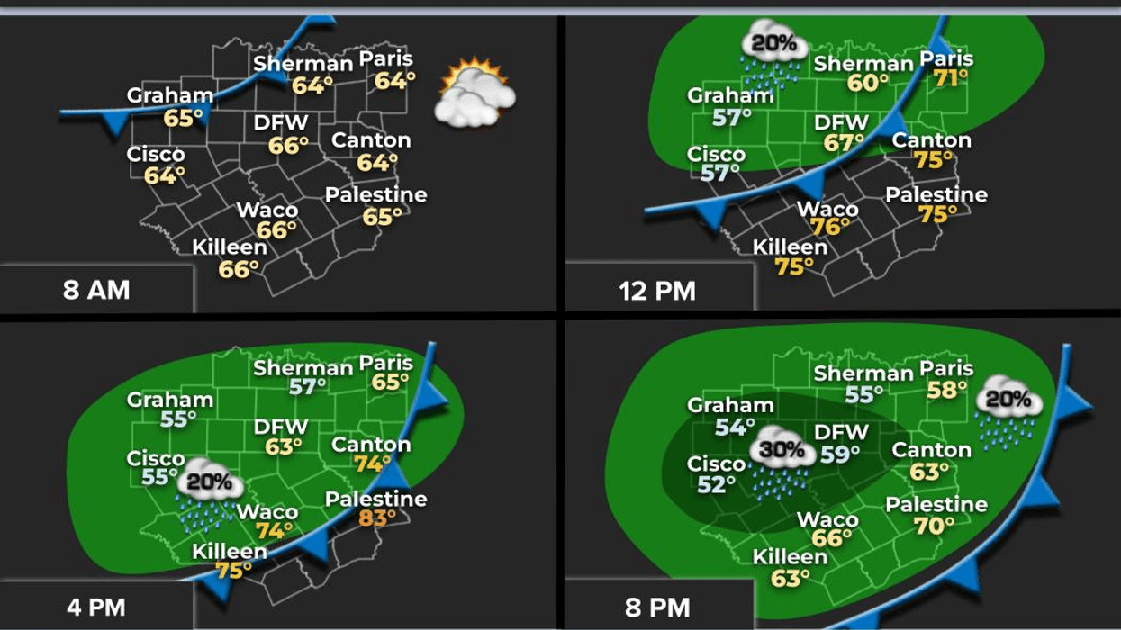
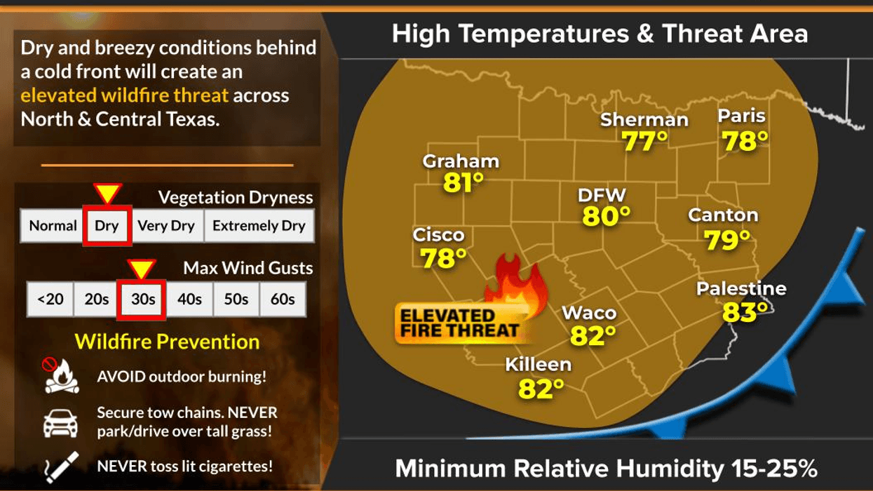
Good morning, ladies and gentlemen. Thank you for joining me today. A dry cold front has moved through our area this morning, bringing a wind shift to the north that will intensify throughout the day, reaching 25 miles per hour and creating a high grass fire danger. Temperatures started in the 60s and will peak near 80 degrees today. Low humidity will make for a great hair day, except for the wind.
Clear skies and calm winds tonight will allow temperatures to drop to the upper 40s to mid 50s tomorrow morning. Plenty of sunshine will dominate tomorrow, with highs in the low 80s, as south winds return.
The wind will pick up on Thursday and Friday, bringing Gulf moisture back into North Texas. This, combined with a weak disturbance late Thursday, will produce scattered strong storms in our northern counties before midnight. Afternoon highs will reach the mid 80s.
Morning clouds and afternoon sun will return on Friday, with highs in the mid 80s once again. By Friday evening, a strong upper level disturbance will approach Northwest Oklahoma, producing a strong line of showers and storms to our west. This large area of rain will move across our area late Friday into early Saturday morning. Some storms may be strong, with a few warnings possible for wind and hail. Heavy rain will also be a threat, with most areas expected to receive at least an inch of rain by Saturday morning.
As of now, this upper level disturbance will be a slow mover, producing wraparound moisture with scattered showers through much of Saturday. Afternoon highs will reach the mid 70s. Nothing severe is expected on Saturday.
Sunday and Monday look quiet, with temperatures returning to the 80s and plenty of sunshine. By late Monday into Tuesday, our strongest front of the fall season will arrive, ushering in much cooler temperatures. I expect morning lows to drop into the 40s in some areas for Tuesday and especially Wednesday and Thursday. Afternoon highs may struggle to reach 70 degrees each day. I will keep an eye on rain chances by early next week, but as of now, the trend shows little rain. Stay tuned.
Have a great day today and please enjoy the weather when you can, it's the only weather you've got!
7-Day Headlines:
DFW hit 91 degrees on Tuesday.
Morning cold front drops temperatures today.
Isolated storms late Thursday.
Widespread showers and storms late Friday and Saturday.
Healthy rain totals.
Drying out Sunday and Monday.
MUCH cooler next week!!
*Yest Rain: 0.00"; Yest High: 91 Low: 57
*Today's Averages: High: 77; Low: 53
*Record high: 94 (1939, 1979); Record low: 36 (1898, 1917)
*October Rain: 0.24"; Deficit:
*2025 Rain: 28.40"; Deficit:
*Sunrise: 7:38am; Sunset: 6:47pm
Tuesday: Sunny, windy and cooler. High: Upper 70s. Wind: NNE 15-25 mph.
Tuesday night: Clear and cool. Light wind. Low: 48-56. Wind: NNE 5-10 mph.
Wednesday: Sunny and nice! High: Near 80. Wind: SE 5-10 mph.
Thursday: Partly cloudy, breezy, and warmer. Evening storms north of DFW. Isolated severe. High: Low to mid 80s.
Friday: Morning clouds, some afternoon sun. A few showers early. High: Low 80s.
Friday night: Cloudy and stormy. A few storms may become severe with locally heavy rain possible. Lows: 60s.
Saturday: Cloudy and mild. Scattered showers a good bet. High: Mid to upper 70s.
Sunday: Decreasing clouds and pleasant. High: Low 80s.
Monday: Mostly sunny and warmer. High: Mid to upper 80s.
LISTEN on the Audacy App
Tell your Smart Speaker to "PLAY 1080 KRLD"
Sign Up to receive our KRLD Insider Newsletter for more news
Follow us on Facebook | Twitter | Instagram | YouTube