Today marks the commencement of August, and the forecast indicates a persistence of shower and thunderstorm chances throughout the weekend and into next Monday. The primary threats associated with these storms include isolated flooding, hazardous lightning, small hail, and gusty winds.
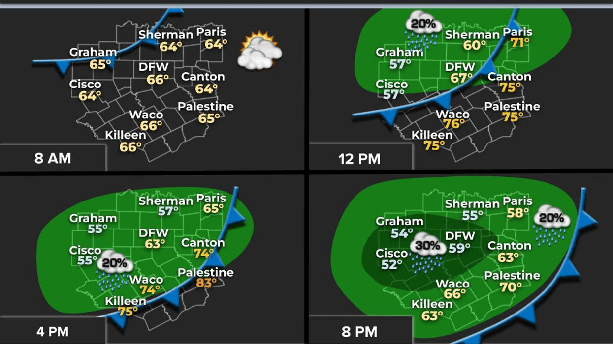
We are concluding the month of July with temperatures below average and precipitation levels approximately half an inch below average. As we transition into August, we anticipate a rainy start, with scattered showers and storms redeveloping this afternoon and evening along a stationary front currently positioned across North Texas. Daytime highs today are expected to be significantly cooler than yesterday's high of 104 degrees, reaching only the low 90s.
On Saturday, additional scattered showers and storms will form, primarily along and south of Interstate 20. Afternoon highs will struggle to reach 90 degrees due to the presence of clouds and precipitation in the area.
A complex of storms is anticipated to affect our western counties on Sunday, although most areas are expected to remain dry, with only isolated shower and storm activity possible. Afternoon highs will reach the low 90s.
Another complex of storms will develop in southern Oklahoma late Sunday night and move through our area during the first half of Monday. This will result in a wet start to the new work week. Fortunately, the second half of the day is expected to improve, with afternoon highs again reaching the low 90s. It is worth noting that 97 degrees is the average high temperature for this time of year.
Commencing on Tuesday and persisting through at least the end of the week, high pressure in the upper levels of the atmosphere will rebuild across our region. This will enable temperatures to gradually warm throughout the remainder of the week. Afternoon highs are anticipated to rise into the upper 90s by Thursday and Friday. The rapidity with which we return to triple-digit temperatures will depend on the amount of rainfall we receive over the next four days. It is essential to recognize that higher humidity levels result in lower temperatures but higher heat index values.
Have a great weekend and I encourage you to remain informed about the weather. Please take advantage of favorable weather conditions when they arise, as they are transient.
7-Day Headlines:
* DFW Airport reached 104 on Thursday.
* Heat Advisories are gone for a while.
* A stalling early August cold front.
* Scattered showers and storms through Monday.
* Beat chance Friday and Monday.
* Cooler temperatures!
* Heating up by the middle of NEXT week.
*Yest Rain: 0.00"; Yest High: 104; Low: 79
*Today's Averages: High: 97; Low: 77
*Record high: 107 (2011,2023); Record low: 63 (1936)
*July Rain: 1.52"; Deficit:
*2025 Rain: 22.16"; Deficit:
*Sunrise: 6:43am; Sunset: 8:26pm
Friday: **Air Quality Alert** Partly to mostly cloudy and cooler. Scattered afternoon and evening showers and storms. Isolated severe. Threats: Damaging wind, small hail, isolated flooding, lightning. High: Low to mid 90s.. Heat index: Near 100 degrees. Wind: ENE 5-10 mph.
Friday night: Mostly cloudy and mild. A few leftover showers. Low: Mid to upper 70s. Wind: North 5-10 mph.
Saturday: Mostly cloudy and warm. Scattered showers and storms. Pockets of heavy rain. Highest coverage south of DFW. High: Low 90s. Wind: North 5-10 mph.
Sunday: Partly cloudy, warm and humid. Scattered showers and storms. Best chance west of DFW. High: Low to mid 90s.
Monday: Mostly cloudy and warm. Scattered showers and storms, mainly before 3pm. Threats: Damaging wind, isolated flooding, and lightning. High: Low 90s.
Tuesday: Mostly sunny and warmer. High: Mid 90s.
Wednesday and Thursday: Mostly sunny, hot and humid. High: Upper 90s.
LISTEN on the Audacy App
Tell your Smart Speaker to "PLAY 1080 KRLD"
Sign Up to receive our KRLD Insider Newsletter for more news
Follow us on Facebook | Twitter | Instagram | YouTube